

We use cookies to ensure our website works properly and to personalise your experience. Cookies policy
1Computer Science and Engineering, Government Engineering College Banka
2Electrical Engineering, Government Engineering College Banka
3Electronics and Communication Engineering, Government Engineering College Banka
4Computer Science and Engineering (Internet of Things), Government Engineering College Banka
The rapid advancement in wireless sensor networks (WSNs) has prompted the need for efficient data collection methods, particularly using unmanned aerial vehicles (UAVs). However, clustering the sensor nodes and selecting an optimal path for UAVs to collect data from the cluster heads while avoiding obstacles is a significant challenge. Thus, this research introduces a novel meta-heuristic clustering and UAV path planning to address the challenges (OA-CBEEDC). Initially, randomly deployed sensor nodes in the monitoring region are grouped based on the information related to them namely, energy, neighbor count and strength of signal. Later, the proposed method optimizes these groups into clusters using hybrid Fire-Hawk-Lyrebird algorithm and then focuses on UAV path planning by handling the constraints of monitoring region and introduction of novel Lyrebird Optimization Approach (LOA). Our approach classifies the path into two categories; feasible and infeasible path. Feasible paths are introduced to the LOA whereas infeasible paths are handled separately and feasible path is created for introduction to the LOA again. The novelty in this work is efficient method of clustering the sensor nodes and finding the path feasibility and introduction of LOA for WSN application. Unlike existing approaches, the proposed approach selects strategic points for UAV to perform data collection and also the ordering of these strategic stop points is such that the path length is optimum. The proposed approach showcases its efficiency in comparison to related approaches in terms of data gathering and route distance for varying number of sensor nodes and height of the UAV. The network stability is enhanced by around 20% and the UAV path length and flight time are reduced by 12% and 7% respectively in comparison to the best scheme among related approaches.
Unmanned Aerial Vehicles (UAVs) are now employed in various domains, including precise agriculture, power line inspection, environmental monitoring, and safety surveillance [1–3]. Given that each application has unique requirements such as long endurance, low energy consumption, high maneuverability, and stability it is challenging to incorporate all these benefits into a single Unmanned Aerial Vehicle (UAV) [4], [5]. Consequently, the development of various drone types has emerged, including Ver-tical Takeoff and Landing (VTOL), Horizontal Takeoff and Landing (HTOL), hybrid designs, and bio-inspired UAVs. UAV-based target positioning methods fall into two main categories: active and passive [6]. Active methods involve equipping UAVs with professional sensors like laser range finders and radars to directly measure the distance to the target. Passive methods rely on optical sensors, such as multi-spectral or infra-red cameras, and can be further divided into monocular and stereo vision approaches [7]. Monocular vision methods utilize a single camera and calculate the target’s position relative to the UAV using techniques like triangulation or depth estimation with neural networks [8]. Stereo vision typically involves binocular cameras or simulates them using photos captured by monocular cameras from various positions. By analyzing parallax information, the position coordinates of the target can be determined [9]. Active target positioning methods, which require UAVs to carry high-precision sen-sors, significantly increase costs and power consumption while limiting flight range [10]. These methods are unsuitable for large-scale target positioning. Additionally, stereo vision localization using binocular cameras faces limitations related to base-line length. A shorter baseline cannot accurately calculate depth for distant targets, while a longer baseline affects UAV flight stability and feasibility [11]. Still, every approach comes with its own set of limitations. Active target positioning methods, which require UAVs to carry high-precision sensors, significantly increase costs and power consumption while limiting flight range [10, 12]. These methods are unsuitable for large-scale target positioning. Additionally, stereo vision localization using binocular cameras faces limitations related to baseline length [13]. A shorter baseline cannot accurately calculate depth for distant targets, while a longer baseline affects UAV flight stability and feasibility. The stereo vision localization method based on monocular cameras relies on UAV displacement to achieve stereo vision [14]. However, it does poorly for moving object localization due to significant time differences in acquiring stereo vision images [15]. Similarly, the monocular camera-based triangulation method requires known reference scales for constructing spatial triangles, and monocular depth estimation depend on scene similarity and suitable scale information. Consequently, both methods are unsuitable for complex target localization [16]. These algorithms should predict low-activity periods without compromising the net-works responsiveness to sudden changes or data requests. Another technique involves energy harvesting, where UAVs and sensors extract energy from environmental sources like solar, wind, or vibrations. While this offsets energy usage, it may add weight and complexity to the UAVs [17].
Over time, WSNs have been extensively utilized to collect data across various application domains. [18]. Employing UAVs in conjunction with a WSN architecture can enable accurate monitoring services in many different types of economic and human interaction domains, such as environment monitoring, security, surveillance, and search and rescue operations [19, 20]. The results are better for both amount of data collected and time for data collection [21]. Literatures referred it by a variety of names, including aerial robots, drones, UAVs, and aerial platforms. There are several constraints to overcome when integrating UAV with WSN, such as data gathering, trajectory planning, and obstacle avoidance strategies [22]. In the presence of obstacles, optimal selection of stoppage points and route finding are primary goals during UAV trajectory planning and data acquisition. Diverse tasks can be performed using this integrated system, but this will lead to concerns about consistent functioning and mission accomplishment in a complex environment (even with the obstacles) [20]. This makes it difficult to meet the operational limitations [23]. It is both vital and challenging to find an efficient path in a scenario with full of obstacles and to make sure the path can cover the designated stop sets in an efficient manner. Battery life is a key domain in the design of WSNs, hence it is difficult to handle both data transmission and extend the life of WSNs. Data collection in WSNs poses challenges due to the difficulty and cost associated with maintaining an existing communication infrastructure or establishing a new communication zone [24]. Data communication significantly contributes to energy consumption in WSNs, resulting in a costly data delivery process characterized by excessive delay in large WSNs [25, 26]. UAVs has a feature of unrestricted mobility, due to which it is frequently utilized to fly and operate over a large monitoring network region and gather effective data from the terrestrial WSN [27–29]. UAV-aided WSNs utilize UAVs as sinks to collect data from terrestrial WSN nodes. The advantages of utilizing collaborative systems for large-scale monitor-ing have been emphasized, since they enhance mobility, accessibility, and efficiency of data aggregation. The sensor nodes (SNs) are deployed to accumulate data about the monitoring area and communicate to the UAV. The intelligent cooperation of UAV with WSN can result in parameter optimization, including data gathering, obstacle-aware communication, and energy consumption [28, 30].
Hence, it is vital to explore these concerns and to suggest appropriate data gathering schemes. This helps not only in enhancing the efficiency of whole operation but also increases the lifetime of WSN. Over all, it can be established that the key challenges for achieving UAV-aided data gathering in WSN comprises the UAV route designing, UAV flight time, impact of obstacles, consumption rate of energy for both UAV and sensor nodes, communication among the sensor nodes and amidst the ground sensor nodes and UAV.
In several literatures, it is presented that UAV helps in extending the range of monitor-ing area and enhances the output of whole network. In this respect, several researchers proposed methods for employing UAVs to collect WSN data, with a primary empha-sis on path-planning algorithms to optimize the path that a UAV will follow [31–33]. However, the practice of employing UAVs is not effortless since the energy efficiency amongst the UAV and the terrestrial WSN has to be tuned carefully. The task at hand involves maintaining a stability between the energy consumption and data gath-ering efficiency of UAVs from WSNs by implementing solutions that optimize UAV trajectory, minimize flight time, and minimize delay in data transfer. However, the UAV’s trajectory planning and WSN organization have a considerable impact on the system’s performance and energy efficiency [34]. Although scholars have keen interest in WSN and UAV, work on trajectory planning and optimization is still underway. These studies differ over both the optimization scheme used as well as the objec-tive function exploited. Furthermore, in WSN monitoring area, various obstacles may exist and these obstacles can significantly affect the performance of the network [20, 29, 31, 35, 36]. Still, there remains an open challenge in determining the path for UAV in 3D scenario with obstacles such that performance of the terrestrial WSN is up to the mark. It is critical to find a solution to this issue in a dynamic environment with obstacles and achieve better service lifetime. In the UAV–assisted WSN data col-lection, it is again a naïve method to gather data from each sensor that is deployed in a large area. It is both troublesome and time consuming for the UAVs.
In this study, we suggest a collaborative UAV–WSN system driven by the present changing needs for monitoring and data collecting from large-scale geographical areas. The following factors need to be taken into account while designing a trajectory for a UAV in order to ensure effective data collecting from WSN. To gather WSN data, the UAV must fly above the selected rendezvous sites (RPs). Optimization of the trajectory length can further enhance the efficiency of data collection while lowering energy usage. Moreover, the path should be obstacle-free and each RP guarantees that effective WSN data is gathered from these RPs.
A well-curated trajectory for UAV-aided data collection can significantly enhance the performance along with energy efficiency of the system. This work proposes a UAV-based data collection algorithm for WSN with Obstacles termed as Obstacle-Aware Clustering-based Energy Efficient Data Collection (OA-CBEEDC) to optimize the energy dissipation, data collection time and enhance network sustenance time simultaneously through the construction optimal clusters along with valid and obstacle-free route for UAV. The core uniqueness of the work is cooperative approach for UAV–WSN data gathering, which incorporates a convenient method for cluster formation and UAV route selection in three-dimensional environment with obstacles. The work proposes a hybrid Fire-Hawk and Lyrebird optimization approach for clustering purpose and meta-heuristic approach based on lyrebird algorithm to select obstacle-free as well as optimal path such that both UAV flight time and sensor node lifetime can be enhanced. The UAV collects data from the RPs keeping communication constraint in consideration and RPs are designated point where UAV hovers and collects data from the set of CHs. The UAV travels from one RP to another avoiding obstacle such that the path is obstacle-free as well as optimal. This approach enhances network lifetime, flight time as well as reduces data latency. Similar to other swarm-based algorithms, the proposed algorithm is a population-based approach that comprises key phases including initialization of population, computation of the cost fitness of individuals, search space exploration, exploitation and termination. The pro-posed optimization method is still different from the present optimization approaches. Among the recent algorithms, most of them largely employ the direct and shortest flight path length as the primary objective to model the ideal UAV route for data collection purpose [20, 21, 29, 37–39]. The key concept behind using this objective is that the shortest path will lead to minimum movement of UAV, this in turn leads to minimum energy consumption of UAV-WSN. But this approach ignores the fact that UAV consumes energy when head direction deviates [21, 29, 36, 38–40]. This work focusses on reducing both the length and angle cost of the path, minimize the energy consumption, and data latency. It includes operations like, decision making, fleeting and hiding, substitution and tuning and finally fine-tuning operation to discover an optimal route that is obstacle-free as well. The hiding phase is further divided into two stages where the algorithm decides either to explore or exploit the search space. This results into global optimum result and algorithm refrains from producing local optimum result. The best trajectory of UAV is obtained such that the path length is both obstacle-free and optimal, while reducing the data latency and optimizing the network lifetime along with flight time. The outcomes demonstrate the success of OA-CBEEDC method in terms of path length and data gathering efficiency when compared to other equivalent approaches. The major objectives of the proposed work are:
The organization of the research is: Section 2 and 3 details the related works with the problem statement and the detailed proposed methodology is presented in Section 4. The simulation result with analysis and discussion is presented in Section 5 and finally, the conclusion and future direction is presented in Section 6.
UAVs have become a prominent area for research in recent years due to their low cost, ideal maneuverability, and flexible deployment. As collaborative UAV–WSN systems advancement, researchers are drawn to addressing new problems and analyzing the trade-off between performance and efficient use of resources [20]. The incorporation of UAVs with WSN has aided in the creation of applications that demand significant improvements in response time, data communication performance, efficiency, and flexibility [20, 29, 38, 41]. In certain geographical settings, such as remote, hostile, and harsh places, UAV-WSN collaboration is an effective means of data gathering, communication, and relay. The design of trajectory depends on the type of UAV used. Circular or rectilinear UAV routes are intended to offer extensive coverage and back-haul connections to additional nodes via multi-hop transmission [27, 42]. However, some efforts have employed UAVs that possess the ability to move in any direction and hover at a particular point. As a result, the path of these UAVs can be randomly selected over a monitoring region or by locating and connecting a group of UAV hovering locations [43, 44]. Nodes in WSN are deployed randomly over the network zone, hence UAVs can adapt more effectively considering monitoring region dimension is large. Furthermore, by concentrating on UAV hovering location, which influences UAV path distance and node energy consumption for data transmission, UAV trajectory may be improved to enhance network performance, save energy consumption, and prolong the operational lifetime of WSNs. It is always a challenge to find methods for efficiently and quickly transmitting sensor data to the sink. The literature contains variety of routing strategies for UAV-assisted WSNs [28]. Effective routing protocols is a must for improving the cooperation between UAVs and WSNs for aerial collection of data. Furthermore, the routing protocol’s energy efficiency and performance are greatly impacted by the way in which WSN is organized and UAV trajectory planning is carried out [34]. Over the past decade, the challenges of determining the best trajectory planning for UAVs under various restrictions has inspired a lot of research interest [20, 21, 29, 38, 39]. The optimization techniques and objective functions vary depending on the applications. To determine the best routes for a mobile node to gather data, several studies were conducted. For path planning, the most popular approach is to use the Traveling Salesman (TSP) formalization of the problem [45, 46]. In regard to this, path planning may be characterized as a TSP problem. It is difficult to solve a TSP, hence it can be regarded as an NP-hard problem [47]. Algorithms that solve TSP include precise, approximate and heuristic algorithms. The most popular types of these algorithms are heuristic and approximation algorithms. The work in [45] designed a model that employs UAV as data accumulator in WSN. Multi-objective function is used by the UAV to build the path, such that the energy consumption can be balanced among sensor nodes and the UAV. In [48], the authors explored different frameworks and strategies using UAVs to gather data that reduced latency in WSNs. The approach gathers data from each sensor node using UAV. This extended the network lifetime due to minimization in communication distance. However, the path length increased significantly. To moderate UAV flight length, some sensor positions were designated as UAV hovering site for data collection [43, 44]. Still, their suggested routes cannot be adopted when direct connection between sensors doesn’t seem possible, and this can significantly raise the energy use at each sensor in the UAV hovering site. Another method, as in [49], identified UAV hovering locations in a way that allowed the UAV to use time-division multiple access (TDMA) to connect with numerous nearby sensors at each hovering point. To locate UAV hovering points, Obstacles are depicted in [35] as barriers in the area; if a region has impassable barriers, the UAV is unable to fly over it. The utilized the grid approach to simulate the flight area, with the suppositions being that every step takes up the complete grid in the intended path and that the obstacle’s position and size remain constant throughout the UAV’s flight. The work [36] presented an energy optimization approach for UAV-assisted data collection in WSN. They utilized particle swarm optimization to create node clusters and extracted the best topology to minimize energy consumption. The work in [41] presents a combined optimization strategy for enhancing the lifetime and data collection latency. [34] ensured that a specific amount of data is reliably collected from each sensor node and also controlled the energy dissipation of sensor nodes. The design is expressed as a non-convex, mixed-integer optimization problem that is challenging to solve optimally. To find a suboptimal solution, the successive convex optimization technique is used, and an effective iterative algorithm is created. The information age (AoI) of the ground WSN nodes was employed by the authors of [50] to gather data via UAV. The time passed since the UAV departs from a particular node and the data uploading time are the parameters that are used to calculate the Area of Interest (AoI). They used two different methods to create the trajectories: dynamic programming (DP) and genetic algorithms (GA). The energy efficiency maximization problem in UAV-aided data gathering was presented by the authors of [51], taking into account the fairness between the cluster heads that interface with the UAV directly. In [52], UAV acts as a relay node for the ground sensor nodes. To reduce packet loss, the nodes in the UAV’s coverage area were split up into distinct groups based on their locations and variable transmission priorities. The following five elements make up the core framework for UAV-assisted data gathering described in [46] network deployment, node positioning, anchor point searching, UAV rapid path planning, and network data collection. To improve path planning efficiency while ensuring a reasonably short path length, they presented the grid-divided Fast Path Planning with Rules (FPPWR) method. Additionally, they verified the efficacy in terms of the acquired data volume, UAV path length, and data gathering time. In order to accomplish more effective data collection of the WSN, a UAV–WSN collaboration network was built in [53]. The UAV was utilized to gather data of the WSN and updated the UAV movement in accordance with the feedback data of the WSN. [47] examines and modifies UAV relay WSN based on NN-heuristic TSP algorithm (NN, DNN, and DDNN schemes) to improve data collection performance by shortening the path length, allowing for faster data delivery. [54] suggests a data gathering strategy where a UAV collects data from a group of sensor nodes that are encountered in a straight line. Their goal was to minimize the flight time, and they demonstrated that in the whole network containing numerous sensor nodes, the flight time minimization problem could be formulated as a DP problem. For each level of the DP, the subproblem becomes smaller and smaller until it can be solved with just one node. The benefits of collaborating the WSN with UAV were covered in [55][56]. Research is done on potential solutions for disaster management systems, and also presents problems and difficulties that are still to be resolved. In [57], a virtual grid point-based method is employed that is energy-efficient UAV-based data collection method. The path planning enables the UAV to visit optimal grid points for data collection purpose. Another method, known as spiral path planning, was put forth by the authors of [32] to plan the UAV path for nodes that are uniformly distributed over a circular region. They concentrated on rapid path planning using the appropriate grid division, and the outcomes demonstrated the efficacy of scheme in large-scale WSN environments. In [40], a k-means based clustering strategy is utilized, and a UAV is employed to gather data by flying over predefined cluster leaders. The best trajectory for the UAV is determined using the simulated annealing technique. [58] presents a strategy where UAV collects data from a designated point. Initially, the nodes are grouped based on neighbor distance and the protocol decides designated points such that each group leader transfer data to the UAV when UAV is in communication range. The literature also formulated a method using evolutionary algorithm to avoid obstacles such that the path is feasible and ensured optimal data latency and flight path.
The primary motto of the optimal path planning algorithms is to construct low cost as well as shortest path. While some of the existing algorithms were successful in achieving this, few of them focused on increasing WSN lifetime and efficiency [20, 27, 37, 59], while others examined UAV energy consumption aspects [31, 59]. Several studies demonstrated that the data collection efficiency is significantly impacted by the UAV’s trajectory; however, few studies have assessed the impact of obstacles while developing collision free route in UAV–WSN collaboration [20, 21, 29, 31, 35, 36]. In [35], the literature performs exhaustive search in grid-based large scale WSN due to which the outcome was not efficient enough. Moreover, the existing methods [36, 40] utilized the minimum path length as the primary objective to construct the optimal UAV trajectory for data collection from sensor nodes. However, not only the path length but also the UAV head angle change impacts the energy consumption of UAV-WSN and data gathering time of UAV. Most of the existing strategies as in [35, 36, 40] have not analyzed the impact of angle change. It can be concluded that the UAV enabled data gathering in WSN comprises challenges like UAV flight time, energy efficiency, impact of obstacles, UAV trajectory designing and data exchange among the UAV and WSN. Thus, it is important to address these issues and to generate appropriate data gathering approaches for enhancing the lifetime of WSN. For making proper data gathering process, it is necessary to plan the path of UAV in optimal manner.
Recently, meta-heuristic algorithms are becoming more popular because of its efficient searching criteria for reaching the optimal target. Thus, it motivates to utilize a hybrid meta-heuristic optimization approach for clustering and UAV path planning to make efficient data gathering process. Therefore, this paper considers the issue of energy and data collection efficiency, as well as the viability of the UAV path for data gathering in an environment with obstacles, is a crucial one that requires adequate research focus. To this end, we explore the obstacle-aware data collection strategy in WSNs using a UAV as a flying data collector. This work proposes an efficient approach (OA-CBEEDC) where an improved meta-heuristic algorithm is designed to construct the best collision-free trajectory for the UAV through which it traverses and collects data. The UAV conducts traversal and collection via designated rendezvous sites (RPs) inside a three-dimensional dynamic environment containing obstacles, which is both optimal and minimal collision-aware trajectory concerning both distance and angular cost. Towards this goal, this paper devises a clustering approach and on top of that a obstacle-aware trajectory is constructed that minimizes data transmission latency, allowing the UAV to hover near the RPs for data acquisition, while optimizing the energy consumption of nodes in the wireless sensor network. The path is further tuned such that the obstacles are avoided along with optimized path length by using various stages of optimization. The protocol guarantees adequate communication time limitation as well as the obstacle avoidance constraint. The outcomes related to path length and data gathering efficacy is outstanding for OA-CBEEDC against other comparative approaches. Due to an efficient UAV trajectory and less energy
consumption, the network lifetime is greatly increased, and more data is gathered from the entire WSN.
4. UAV-assisted effective data gathering scheme
This section discusses the proposed OA-CBEEDC scheme where effective UAV-based data collection is performed in obstacle-present WSN. This paper addresses the key issues such as network lifetime, energy efficiency, data latency for WSN and obstacle avoidance for UAV movement. Figure 1 illustrates the UAV-supported data collection scenario where a UAV gathers data from a selected point (RPs) such that more than one cluster head can send their data in a particular time frame. After collection from a particular RP, the UAV moves to another RP. During this movement, UAV may encounter obstacles and this scheme optimizes the path such that obstacle get avoided along with the path length is also optimal. This challenging optimization problem is handled using meta-heuristic approach. The obstacles that are present in WSN environment degrades the communication quality among sensor nodes as well as between sensor node and UAV. This scheme guarantees good quality communication between UAV and sensor node by avoiding the obstacles.
Fig. 1 UAV-aided data collection.
To ensure the network efficiency, information about obstacles and RPs is required so that optimal and feasible path can be constructed. In some existing optimization algorithms, energy consumption of the UAV is represented by the length of the trajectory. Different from earlier studies, we determine the optimal trajectory for the UAV to fly and collect data from the chosen rendezvous points (RPs) using an meta-heuristic approach considering the problem of energy consumption and the viability of the UAV path into consideration. Firstly, we provide the system model and the unique features of the suggested OA-CBEEDC approach. The UAV collects data by hovering close to the RPs while balancing the network’s energy consumption in an effort to decrease delay in data delivery and enhance performance. Thus, it is possible to increase the amount of data acquired from the whole WSN while decreasing the path length that the UAV moves during data collection. The initial step in this work is to create the groups of sensor nodes, select respective group heads and then based on group heads optimal hovering points are determined for energy efficient data communication with UAV. Then, a meta-heuristic method based on lyrebird algorithm is designed to plan trajectory for the UAV to improve the energy transmission efficiency and performance of the entire network. Let Plength denotes the path length traversed by the UAV. The path length directly impacts the amount of time the UAV can fly, which in turn impacts the network longevity, energy efficiency, and data gathering efficiency. Therefore, Plength is as given in Eq. 1. However, the cost determined is invalid if the path has obstacles or prohibited areas since it cannot be acceptable.
Plength=∑Px1,x2
Where Px1,x2 denotes the Euclidean Distance between the RPs x1 , x2 in the path. We remark that Px1,x2 depends on the order of visit of RPs x1 and x2 in a given path. Moreover, the path should be free from collisions with surrounding obstacles.
Plength∈Ofree
i.e. Px1,x2∈Ofree .
In this work, we represent a UAV with U, and a set of n randomly deployed sensor nodes N = sn1, sn2, sn3, .., snn in an area A, and obstacles are denoted by O = o1, o2, . . . , om , where m, n are number of obstacles and sensor nodes respectively. After sensor node deployment, the location of sensor nodes is obtained with the help of GPS or some localization method. Moreover, the size of obstacles is known in the form of oi= oxmin, oxmax, oymin, oymax, h , where i = 1 to m and h is height of the obstacle. We can calculate the size of obstacle using this format and it will be helpful in upcoming stages of algorithm design. The location coordinates of sensor nodes SNi denoted by xi, yi satisfies the condition xi, yi∉oj ; j = 1, 2, . . ., m. With effective communication range of R, nodes communicate to each other and with the UAV. The path planning is such that sensor nodes perform radio communication with the UAV when it is in communication range and there is no hindrance due to obstacle. The term obstacles in this paper refers to the physical structure that hinders the route of a UAV and reduce the signal strength between sensor nodes. As a result, the UAV has restricted movement, and sensor nodes can only interact when the RSSI value is within an acceptable range. To mimic the real-world scenario, we represent the structure of an obstacle as a polygon instead of circle, square or other geometrical shapes. It is important to design the UAV path to make sure that it does not cross over any existing obstacles. This can be expressed as Plength∪∩mj=1 oj ≠ Ψ. The first step in the overall process is to group the nodes and then form the optimal clusters using hybrid Fire-Hawk-Lyrebird (FHL) optimization and then determine the respective cluster heads. Based on the location of cluster heads the position of RPs is decided. These RPs are the point from where UAV collects data of all sensor nodes through a set of cluster heads, also the route of the UAV depends on these RPs to deliver data to the base station. During the UAV movement, UAV transmits a beacon message to inform its arrival and the cluster heads that are present in effective communication range to the particular RP starts transmitting their data. We assume that sensor nodes could cooperate with UAVs and among themselves during the data collection process. The UAV movement is along the planned trajectory that is determined by the proposed algorithm. Fig 2 illustrates the overall algorithmic stages and different steps in each stage.
Energy consumption of UAV-WSN The energy dissipation and radio communication channel of the system is modelled similar to the model used in [36, 37, 48, 58, 60]. For a message of l-bit and distance s is given below, where s0 is the threshold distance. Ee is the energy utilized by the electronics, ϵα and ϵβ are the amplifier energy for two different cases based on threshold distance. In our scenario, due to the use of UAV; sensor nodes are restricted from performing long distance transmission to the base station. Consequently, the nodes utilize less energy while transmitting data.
ETXl,s=l*Ee+l*ϵα*s2&,s<s2l*Ee+l*ϵβ*s2&,s≥s2 (3)
ERXl,s=l*Ee 4
However, the UAV consumes most of its energy while flying and collecting the data from a particular RP. The energy consumed by the UAV to travel from the current RP to the next RP is determined by the equation Eu=Pu*srp,rqvu where Pu and vu are power rate and speed of the UAV. The distance between two consecutive RPs is represented by s (rp, rq). The UAV may perform an angle (or head direction) change around RP or due to the influence of obstacles. This will also lead to consumption of energy of the UAV [37, 48, 61]. To optimize the energy consumption of the UAV,
the best possible way is to construct feasible and straight path. This will reduce the flying distance under keeping flight speed constraints in consideration [40, 48, 54]. The influence of obstacles and shadowing should not be ignored when UAV and sensor node communicates in complex environments because it can impact the ground-to-air (G2A) channel [36, 48]. The Line of Sight (LoS) communication probability depends on the elevation angle and the environmental factors. The angle formed between UAV and sensor nodes is the elevation angle whereas obstacles, wind speed, threats are
environmental factors. The path loss is influenced by the elevation angle such that, as the elevation angle θ increases the path loss exponent α may decrease. G2G links with θ = 0 and G2A links with θ = π/2 may experience the largest α (denoted by α0), and smallest α (denoted by απ/2) respectively. Based on [62], the general formula for probability of LoS for path loss exponent α(θ) is represented as in equation Eq.5
ρLoS θ=11+ μ2e -η2θ (5)
θ=180π*sin-1hdpq (6)
dpq=xp-xq2+yp+yq2+h2 (7)
where the coefficients μ2 , η2 and dpq represents constants, environment characteristics, carrier frequency of the signal and variables, distance between UAV and particular sensor node.
4.2 OA-CBEEDC algorithm design
Here, we present the Obstacle Aware Cluster-based Energy Efficient Data Collection (OA-CBEEDC) algorithm in detail. The algorithm is primarily divided into two stages: stage (i) Initialization and stage (ii) UAV path designing, that is discussed below and Figure 2 illustrates overall flow of the algorithm.
Fig. 2 Flowchart for OA-CBEEDC scheme.
Stage 1: Initialization
Node grouping and group head selection: The WSN is depicted as an undirected graph G = V, E , where nodes are represented as vertices V and links among them are visualized as edges E. If the number of sensor nodes is N then a node can have maximum EN-1 edges or communication links. Here, sensor nodes are restricted to communicate with neighboring sensor nodes within its effective communication range limit R. If SNi have maximum Nr sensor nodes in its proximity then the relationship can be denoted as: dist SNi, SNj . This relationship gets affected due to the presence of an obstacle(s). The existence of an obstacle within R impacts the direct communication link quality due to the hindrance to waves responsible for data communication. Moreover, improper selection of the RPs may result in increased UAV path length which will consequently increase the energy consumption of the UAV. Therefore, the distance calculation and quality of communication need to be evaluated to analyze the impact of the obstacles. Prior to the selection of RPs, the nodes are grouped based on proximity measure and link quality. Grouping of nodes begin with data exchange between node and its neighbors. This step is followed to get neighbor list for each node SNi . The data exchanged by the neighbors contain node ID and node coordinates. Whenever a sensor node receives information from its neighbor, the node updates its neighbor table with these details. Based on the node coordinate, each node then calculates the link quality by deriving the RSSI value and adds this value against respective node information. Higher is the RSSI value means higher is the signal strength. These are primary information while performing node grouping and group head selection. Later, these groups are formed into optimal clusters and cluster heads using objective function and hybrid Fire Hawk- Lyrebird optimization method. Subsequently, based on the cluster heads, RPs are determined by calculating the obstacle-free minimum distance point such that position of the RP is within communication range R of a set of cluster head. From Figure 3 it can be visualized that minimum distance point is the initial RP (red color) is selected keeping in consideration three cluster heads but due to the presence of obstacle, final RP (green color) position is obtained such that impact of obstacle get mitigated. More details regarding RP selection are provided later in this section.
After getting the information from valid neighbor list, a sensor node SNi calculates the chance of becoming group head using the equation 7
ChanceGH=ω1*SNienergy+ω2*SNinbr+ω3*SNideg
Fig. 3 Selection of RP at safe location.
where omegas are weighing factor such that ω1+ ω2+ ω3=1 , SNienergy is normalized value for residual energy, SNinbr is node degree and SNideg reciprocal of average distance between the node and the eligible neighbors. The chance of node to become group head depends on the value of ChanceGH and this relation is directly proportional, that is, greater the value, higher the chance. To decide the number of announcements and subsequent energy dissipated by each node, we analyzed the energy consumption details analytically during the group head selection process. For this purpose, we assumed that energy consumption due to computation by sensor node is nominal and it can be ignored in comparison to energy consumption due to data transmission. Initially, each sensor node makes an announcement with its node ID and coordinates within its communication range. According to first order energy consumption model [19, 20], energy consumed by each node for announcing its information and receiving Nr number of information can be calculated using equation. Therefore, based on the analysis, this work keeps the value of number of announcements to t = 5. All neighbours of declared group head are not allowed to participate in the grouping process. Furthermore, this step is repeated for rest of the nodes. Finally, Gk groups are created with GK= g1, g2, . . . , gk and each group has a group head K = k1, k2, . . . , kk . Each SNi ∈ K , if any sensor node Sj does not become member of a group, then it is considered as single member group where Sj is the group head. These groups are fixed throughout the WSN operation. Now, UAV traverses the network region and selected group heads transmit its node ID and also of the members, declaring that they are the group heads. After getting the node ID of group head and respective members, rest of the computations are performed by the base station, namely, next round group head selection and constrained trajectory planning.
The BS is responsible for designing and executing the FHL-based clustering protocol. In this protocol, this paper assumes that the BS is aware of sensor node status (i.e. position and energy). The energy status is calculated by the BS based on energy dissipation rate as per the Eq. 3 and 4 and position information is known through initial group head information gathering. The second presumption is that there are a fixed number of clusters (m clusters), and that these clusters are shown as c1, c2…, cm . Moreover, the role of CH is rotated whenever energy level of current CH reduces to 50% of previous energy level. This stabilizes the energy discharge rate of cluster head and balances the load distribution. Due to this, all the nodes within a cluster get chance to become cluster head. Furthermore, the FHL algorithm is run by BS to identify the best CHs in the network whenever a cluster head dissipates its 50% energy. The following are the various stages of the clustering protocol:
Step 1: Population initialization In this step, BS considers candidate solutions, CSi, that are corresponding to fire hawks and prey. In the CH selection problem, each fire hawk or prey is considered an array with m elements (m indicates the number of CHs). In this array, each element includes the ID of a sensor node (such as snj). This ID is randomly selected from a candidate CH set called Candidate Cluster Head (CCH). The CCH is formed by randomly selecting sensor nodes (SN) from the group heads and sensor nodes that are eligible for group head selection (as mentioned in Eq. 1). As a result, targeted nodes with high chance of becoming cluster heads are selected as possible optimal CH.
Step 2: Evaluation process Each potential solution is assessed in this step using the objective function shown in Eq. 25. where σi ∈ [0, 1] are weighted coefficients and σ1+ σ2+ σ3+ σ4 = 1.
fobj= i=14σifi
In this paper, the target is to minimize the objective function fobj to get the optimal solution. The Eq. 8, presents fobj as linear equation with four variables f1 to f4. f1 in prefers those sensor nodes as CH that are closer to the cluster center i.e. distance between CH (CHh) and respective cluster members (CMk , Ch) is minimized. Besides that, it also ensures that distance among CHs is maximum and well distributed. The f2 selects the CH that has higher residual energy than that of average energy of CMs. Moreover, f3 tries to make all the clusters equal. This paper uses UAV as a data collector due to which having all cluster equal in size is important. Finally, f4 selects those CH that has minimum energy consumption rate due to transmission, reception and data aggregation. After evaluation of the objective functions over CCH, the best solution is declared as the main fire (GB). Then, rest of the solutions are divided into two classes based on the objective function values: fire hawk and prey. Fire hawks include those objective functions that have least objective function value and rest are specified as prey.
F=F1,F2, …Fl,…Ff
P=P1,P2,…Pq,…Pp
Step 3: Fire hawk territory Each F determines the prey close to itself as its territory. To determine the territory of each fire hawk, the sum of Euclidean distance between the selected CHs in P and selected CHs in F is calculated.
DQl= l=1fq=1p t=1mcslt-csqt2
Step 4: Updating process Here, update process of lyrebird optimization algorithm is included in Fire-Hawk optimization algorithm. The update process is divided into two stages: Exploration and Exploitation as denoted in Eq. 33. where r1 is the random number and ri denotes random number in rest of the paper.
update csi=Exploration, r1≤0.5Exploitation, otherwise
Step 4.1: Exploration Here, the fire hawks (F) are updated such that the target is to get a solution that is better than GB. The updated fire hawk Flnew is denoted by the
Finew=csl1,csl2,…,cslm
Now, the set of safe states are created. This set helps the algorithm to move towards better solution. The set contains those F that have better objective function value for the current fire hawk. This restricts the exploration to all the fire hawk. The safe state is denoted by Eq. 35 and it is assumed that fire hawk escapes to one of these safe areas.
SAi={Si,Fi<Fj and l∈1,2,…,f
where i = 1, 2,… ,p . Now, the modified update process selects sensor node according to the Eq. SAi corresponds to near_to_betterFH, as per original Fire-Hawk Optimization algorithm. This update helps to converge the solution towards optimal solution faster than the original algorithm.
Step 4.2: Exploitation In this step local solution is preferred. The algorithm tries to find better solution available around the problem space. It is similar to the behaviour of a lyrebird that hides within its proximity when it senses danger. Hence, the new position of suitable solution is calculated for each prey. While hiding, there may be possibility for the algorithm to get stuck into local optima. Due to which, cs helps in escaping such situation. Pnew is evaluated using the objective function. If the prey cannot improve the objective function value in comparison to the previous one. pnew is recalculated based on the distance, because the prey may move towards the territory of other fire hawks.
Step 5: Convergence condition The hybrid Fire Hawk Lyrebird optimization algorithm stops when there is no update in the objective function or when number of iterations T is reached. The algorithm returns GB when no solution is found better than it. Otherwise, an optimal solution better than GB is returned. After completion of the algorithm, BS sends state status (SS) message to the sensor nodes and assigns status as CH or CM. After forming clusters, the RP position determination phase starts. These RPs are positions where UAV will hover and collect data from multiple CHs at a time as soon as they receive data from the corresponding CMs.
4.2.3 Stage 2: UAV trajectory planning
This section gives detail for design of efficient trajectory so that the UAV can visit RP-to-RP in an obstacle constrained WSN scenario. After selecting cluster heads and respective RPs, UAV collects data from a set of CHs by visiting the RPs. This approach will help in reducing the flight time, path length of the UAV, along with this data collection efficiency will also increase. After obtaining a set of Z RPs, where each zi covers CHj , and SNk CHl, l = 1 to N , the RPs facilitate data transmission to the UAV instead of visiting every group head. UAV travels to each RP, zi∈ Z and performs data collection process. The movement of UAV is such that more than one cluster head is able to communicate with the UAV. Fig. 5 illustrates the UAV movement along the effective communication range R of CHs, where H is the height of UAV and Θ1 and Θ2 are angles formed by CH1 and CH2 with the UAV respectively. Even though equidistant point is selected as an RP for a set of CHs, due to the movement of UAV closer to the RP that resides inside the intersecting region as shown in Figure 4, the angle formed by CH with the UAV may or may not be equal.
This section describes the UAV route design step, which involves creating an energy-efficient UAV trajectory to visit RP-to-RP in a WSN scenario where UAV movement gets influenced by the existence of obstacles. This paper introduces an improved meta-heuristic algorithm with the objective to arrange RPs such that flight path is obstacle free and flight length is optimal. The primary challenge is to determine the best path where performance of the UAV-WSN collaboration is optimal in terms of path length, obstacle avoidance and energy efficiency. In some of the state-of-the-art UAV-WSN approaches, path length is a primary consideration for energy consumption of the UAV. In this work, we have considered path length as well as angle change as a factor that affect the energy consumption of the UAV. The following are the various factors that this paper take into account when designing a UAV trajectory:
• Route Feasibility Check and the Obstacles Cost: The first step is to determine the obstacles cost so that the status of the path feasibility can be derived.
• Path Length and the Length Cost: UAV path length is the length of the path that
UAV follows during data collection phase.
• Cost of deviation: Whenever UAV changes angle, UAV has to utilize more energy and this extra energy utilization is modeled using cost of angle change.
Fig. 4 UAV route design for data collection.
Path feasibility check and the obstacles cost
While designing the UAV’s trajectory, the primary concern is to ensure that the path does not crosses through any obstacles in the network area. The top priority during UAV path planning is to ensure route safety and obstacle avoidance. Hence, this is the key element for the viability of the UAV route. If the movement of UAV is along any of the coordinates xi, yi as illustrated in Figure 5 then cost of obstacle Cobs is 1, otherwise 0. Hence, if Cobs is 0 then path is feasible otherwise infeasible. Using the coordinates of the obstacle, the movement of the UAV is ensured for minimum distance traversal.
Fig. 5 Feasibility check for movement of the UAV.
Length cost and UAV path length
In order to gather the data, UAV flies to the network area initially from the BS and visits RP in a planned manner, hovers near each RP and finally returns to the base station. The length of the path that UAV has covered in whole mission is termed as UAV path length. Since, obstacles are present in the network area, therefore the actual path length will be different from that of ideal path length. Here, ideal path length indicates that UAV has no obstacle and it can freely move from one RP to another RP without any constraint of collision or communication disturbances. It is evident that higher the path length, higher the energy consumption by the UAV.
Cost of deviation
To calculate the energy consumption of the UAV during data collection, evaluation of path length while visiting the RP in planned manner is not adequate. Since, movement of the UAV from one RP to another is not necessarily a straight path, due to the presence of obstacles and method of selecting RP may enforce UAV to deviate from its original path and change the head angle to reach a specific RP for data collection purpose. When the UAV changes its path due to what-so-ever reason, the energy consumption rate increases in comparison to straight path movement. Let us consider an RP for data collection purpose. When the UAV changes its path due to what-so-ever reason, the energy consumption rate increases in comparison to straight path movement. Let us consider a straight-line joining points a and b which will be the shortest distance between the both points. If any other line drawn besides the straight line, then it will be of larger length. And if, a path other than straight line is chosen for traversal then it will surely have at least one turn or deviation. Hence, it is evident that multiple angle change for a UAV will lead to additional path coverage besides that the propeller of the UAV has to make an additional effort (extra energy usage) to deviate from its trajectory. The UAV changes its angle to avoid collision with obstacles or to reach the next RP which is not present in the current head movement. Moreover, the change in angle is facilitated by adding additional points besides position of the RPs. While planning for traversal order of RPs and designing the UAV route, any intermediate point is nothing but the deviation points which in conjunction with previous and next point forms an angle. Therefore, the energy consumption of the UAV is affected not only due to the flight distance but also due to path deviation. This approach is different from the route designing that considers flight length as an only parameter of energy utilization by a UAV. Figure 8(b) shows an ideal movement of the UAV, where there is no angle change and, in such case, Θ = 0â—¦. Usually, multiple angle change is experienced when number of deviations are high. Also, the UAV experiences high number of deviations when obstacles are present in proximity and next RP is not in the current trajectory. Overall, this causes extra energy dissipation by the UAV and the cost. If number of traversal point is more than two then there will be a deviation.
4.2.4 UAV route planning and optimization algorithm
In this sub-section, we design an ideal route for the UAV that maximizes the effectiveness of the UAV-WSN collaboration while meeting a number of requirements, including energy, time (or distance), quantity of data gathered, and danger (obstacles). Here, we present an enhanced learning lyrebird optimization approach to choose the best route which is feasible and optimal for the UAV-assisted data collection purpose. Multi-objective fitness function for UAV route designing: In the search for the optimal UAV trajectory to perform WSN data collection, it is essential to take into consideration the cost functions established in the sections 4.2.3.1 to 4.2.3.3. The Cobs that is established in section 4.2.3.1 is the base evaluation. After calculating the Cobs, the rest of the costs are calculated, based on the cost of path in 4.2.3.2 and cost of angle deviation in 4.2.3.3, a multi-objective fitness function is given by:
MOF = αCPL+ βCΘ
where MOF denotes a viable fitness cost that includes both path length cost CPL and extra cost CΘ due to angular deviation, that directly influence the data collection trajectory and the energy utilization of the UAV. α and β are weights that satisfies α + β = 1. MOF is used as a primary evaluation method to select the effective UAV path with an aim to minimize the operative cost.
Algorithm 2 presents the pseudo-code for selection of UAV route. Step1, initializes population similar to meta-heuristic optimization algorithm. The population includes coordinates of RP and for each pair of RP feasibility check is performed (step 2). It is because there may be a chance of infeasible path between a pair of RPs due to presence of the obstacles. If Cobs= 0 then, use such RPs for optimal ordering using LOA [63] and MOF (steps 3-8). If Cobs ≠ 0 , for any pair of RPs then call substitution and tuning operation and find eligible intermediate points. Update the population accordingly (steps 10-13). This creates feasible path between each pair of RP. This process ends when maximum number of iterations reached. Finally, we get optimal, obstacle-free, and refined path.
Algorithm 2 Pseudo Code Stage 2
1: Population Initialization
2: Perform the feasibility check for the path.
3: if Cobs = 0 then
4: Determine overall MOF
5: if not terminated then
6: Execute LOA operations
7: Update the population, goto step 2
8: end if
9: end if
10: if Cobs = 0 then
11: Execute Substitution Operation and Path Regulation
12: Update the population, goto step 2
13: end if
Proposed LOA for UAV path planning
The path planning by the UAV is made by considering the obstacles in the path for making the data collection from the sensor nodes more efficient. Here, the path planning is employed using the proposed LOA approach, which considers multi-objective fitness function with path length or length cost, cost of angle change, and obstacle cost are considered as a factors based on feasibility of path. The design of LOA assists the proposed model to obtain fast convergence with the avoidance of local solution trapping; the algorithm explores the search space more effectively. Thus, the LOA is considered in the proposed path planning approach. While considering the LOA [63], two things make lyrebirds particularly remarkable: first, their incredible ability to replicate both man-made and natural sounds from their surroundings. The second, the magnificent beauty of the male’s huge tail, which he fanned out in a mating show. When a lyrebird detects danger, it stops and looks about it attentively. After that, it chooses to either hide somewhere appropriate (Exploitation feature) or leave the area (Exploration Feature). The LOA employs a mathematical model, which involves determining and reacting to danger. The mathematical modelling of the proposed LOA for WSN is detailed below.
Mathematical Modelling: Within the problem-solving area, the initial placements of search agents are assigned arbitrarily. To Explore the whole problem space, the search agents follow random initialization. Searching for the best solution in the path planning space is a collective effort employed by the search agents. The lyrebirds (searching agents) explore the problem space to discover better solutions throughout each iteration of the algorithm. An algebraic matrix can be used to represent the population of the algorithm. Here, each element represents search agent ’a’ and the population matrix is denoted by S. In the matrix S of dimension [(p + 1) (k + 1)], for each pq,r and px,y , if Cobs ≠ 0 then set of tuned supporting points is maintained separately and the LOA outputs optimal order of pq,r and where ever applicable, supporting points are added between pq,r and px,y . Again, MOF is calculated for RP order including supporting points and saved separately. After each iteration, if addition of supporting points lead to better MOF then that MOF is saved, else rejected. The initial position of LOA members is initialized randomly using Eq.
pq,r= Lq,r+ γ0Uq,r- Lq,r
here, pq,r signifies the solution with rth index of the qth lyrebird and the random factor is defined as γ0 with [0, 1] limit. The problem space is defined with the range of lower bound and upper bound of Lq,r and Uq,r respectively, where Lq,r = 0 and Uq,r=NoOfRPs-1 . Here, the RPs are saved in an array and index position of each RPs are denoted by Lq,r and Uq,r . Fitness: The fitness of each lyrebird is calculated using MOF. The fitness calculation ensures that next selected lyrebird position is better than the previous one.
Decision Making: A lyrebird makes its decisions by selecting between hiding and fleeing. Based on the method of decision-making, the population update procedure in LOA is split into two stages in this case:
Fleeing: Departing from the present location to investigate new problem regions inside the search space, a fleeing strategy is utilized. The random selection of RP is per-formed at this stage to solve the issue of local optimum trapping caused by premature convergence in the fleeing stage.
Hiding: Refining the solution locally by the search agents is employed in the hiding phase. The decision for fleeing and hiding is employed based on Eq:
update Pi= Exploration, γ1≤ 0.5Exploitation, otherwise
Exploration: A lyrebird will shift its location significantly when it perceives danger and will relocate to a safe region. This behavior improves the global search capabilities of the algorithm by simulating broad exploration in the solution space domain. The placements of other lyrebirds with superior objective function values based on the better solutions are considered safe zones. By comparing the objective function value of each lyrebird with that of other members of the population, the set of safe places for that bird is established.
Exploitation: The lyrebird uses this phase to precisely analyze its immediate environment and take tiny movements in search of a good hiding place. This behavior is modelled to enhance the algorithm’s capacity to perform local searches or exploits. LOA algorithm fine-tunes solutions inside the immediate region to the movement’s little alterations. Each lyrebird’s new location is determined using its present location and a tiny random modification. With the LOA, the hiding phase modifies lyrebird placements precisely to improve the algorithm’s local search capabilities. Exploitation, improving the present solutions, and making sure they progress towards ideal solutions are the main goals of this phase.
Termination: When the difference between the values of the goal function after each iteration is less than a certain threshold, the algorithm stops. Otherwise, after a pre-defined number of iterations, the algorithm terminates.
5. Simulation parameters and results
The results are obtained by performing the simulations on MATLAB R2024a using Intel(R) Core(TM) i7-10700 CPU @ 2.90GHz processor with 8GB RAM. The simulation is executed 20 times for confidence and average of all output is used as the final outcome. The final result of the proposed OA-CBEEDC is then compared with related approaches: EDGO [58], CF-A*[35], WKMC-SA [40] and PSO-SN [36]. The simulation setup comprises environment where sensor nodes are randomly deployed and varying number of obstacles are created. The network region considered in the simulation is of size 1000m × 1000m, and node count is varied from sparse to dense, that is, from 200 to 1000. Each node in the setup has uniform initial energy of 1 J and size of data packet is 1000 bits. Initially, the flying height and velocity of the UAV is taken as 100m and 5m/s for comparison with existing approaches. The performance of proposed approach is compared based on variable flying height to replicate real-time scenario, because agricultural or energy grid UAVs hover at lesser heights. The performance parameters analyzed are:
• Average route distance with varying sensor nodes.
• UAV flying time.
• Average route distance with varying obstacles.
• Data gathering efficiency.
• Energy consumption.
• Network stability.
• Network stability with varying UAV heights.
The simulation parameters utilized for the implementation is portrayed in Table 1.
|
Parameters |
Range |
|
Number of nodes |
200 to 1000 |
|
Network Size |
1000 × 1000 m2 |
|
Initial Energy |
1J |
|
Data packet Size |
1000 bits |
|
Flying height of UAV (H) 50m, 30m UAV velocity |
100m, 75m, 5m/s |
|
Number of Obstacles (O) |
1 to 5 |
|
Number of Lyrebirds |
Number of RPs |
|
Constants ω1, ω2, ω3, α, β, σi 0.5, 0.25 Communication range, R |
0.5, 0.2, 0.3, 0.5, 87 m |
|
Ee, ϵα |
50pJ/bit, 10pJ/bit/m2 |
|
Number of iterations, T |
100 |
Table 1 Simulation Parameters
5.1 Result analysis
This section presents the comparative results of the OA-CBEEDC algorithm with respect to existing approaches using aforementioned performance parameters. Fig 11 shows the random distribution of sensor nodes with node ID inside network area of 750×750m2. Fig 12 (initial groups) and Fig 13 (final clusters) shows the effectiveness of hybrid Fire-Hawk-Lyrebird algorithm to make efficient clusters. Fig. 14 and 15 shows the node distribution inside WSN area and UAV is shown as a rhombus. Fig. 16,17,18 shows the UAV moving from current location to designated location by moving around the obstacles.
Fig. 6 Average Path Length Vs. Number of Nodes
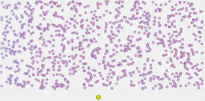
Fig. 7 WSN area with 750 nodes.
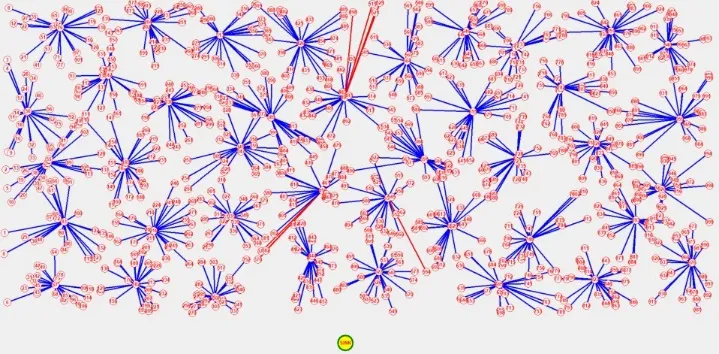
Fig. 8 Instance of initial groups formed with respective group head.
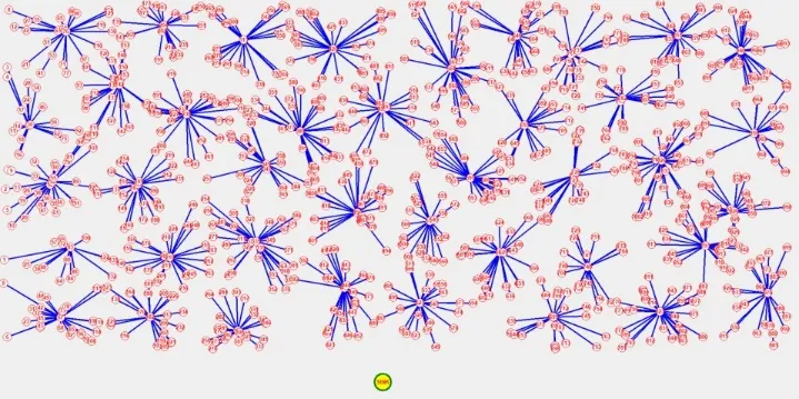
Fig. 9 Instance of final cluster heads selected with respective cluster members obtained after executing hybrid Fire-Hawk-Lyrebird algorithm
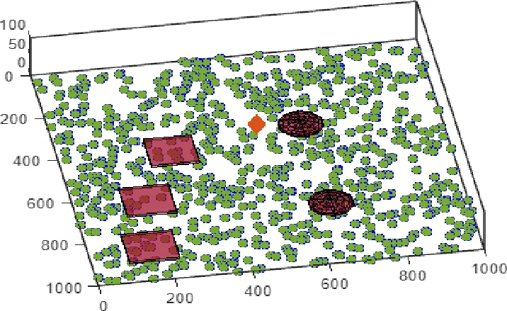
Fig. 10 3D view of WSN area with 800 nodes and 5 obstacles (the rhombus denotes position of UAV).
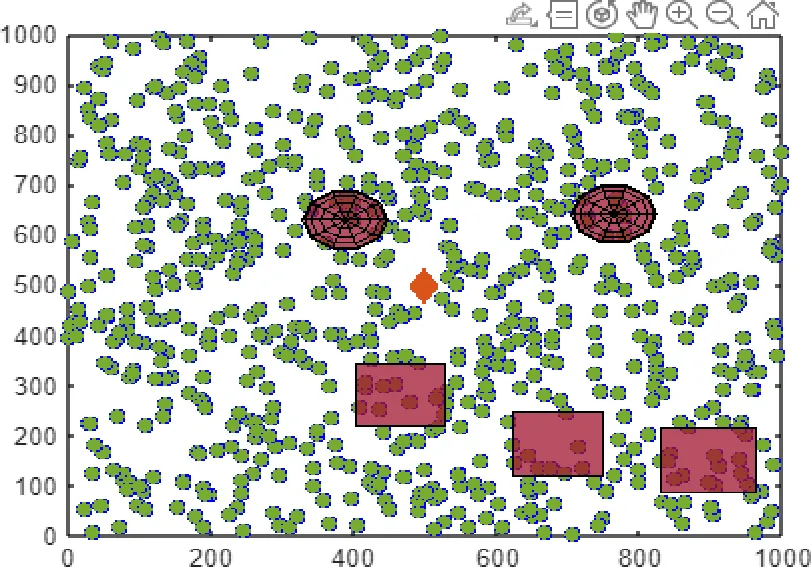
Fig. 11 Top view of WSN area with 800 nodes and 5 obstacles.
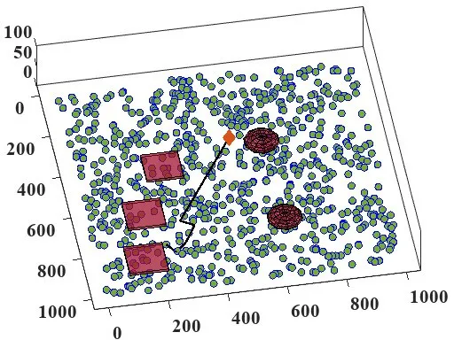
Fig. 12 UAV changing its direction reach the node.
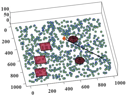
Fig. 13 UAV moving passes closer to the obstacle.
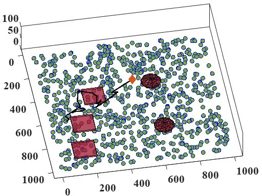
Fig. 14 UAV moves to the node by avoiding more than one obstacle.
Average route distance and flight time In this test, we present the performance of OA-CBEEDC with others on the basis of total route distance covered by the UAV to perform one round of data collection via each RP. In other words, we can say that average route distance is the path length that each scheme generates for data col-lection purpose. To verify the robustness of the schemes, the performance evaluation is also performed for varying number of sensor nodes. FIG presents the performance level achieved by each scheme.
Fig. 15 Average path length (with/without obstacles)
The node count is varied such that performance of the schemes in sparse WSN with 200 nodes and dense WSN with 1000 nodes can be analysed. It is observed that existing schemes generate route of length greater than 5 KM on an average with EDGO being an exception. But our algorithm outperforms EDGO also. It is because, in the case of EDGO, UAV collects data from each group heads whereas OA-CBEEDC scheme collects data from a set of group heads via RP due to which the movement of UAV is minimum among all. Moreover, EDGO employed evolutionary algorithm in contrast to others and our approach employs meta-heuristic lyrebird optimization algorithm. The exploration and exploitation capability of lyrebird optimization is far better than evolutionary algorithm, particle swarm optimization, simulated annealing and A* search. It is worth noting that EDGO scheme performs grouping in distributed manner whereas our scheme selects first GH in distributed manner and in rest of the rounds GH role is announced by the base station. Due to better capability of our scheme, we can say that the path length generated is of shorter length in comparison to others.
Fig. 16 Average Flight Time (with/without obstacles)
Obstacle impact Obstacles create hindrance in movement of the UAV, data collection process between UAV and sensor node and ultimately affects the flying time. We conducted a comparative analysis of the average length of the path produced by the algorithm in various circumstances, including those ‘with’ and ‘without’ obstacles. The findings are presented in FIG. We demonstrate the increase/decrease in the path length generated under obstacle-present and obstacle-free scenario. In obstacle-present scenario, the length of the path generated by current approaches are longer, with EDGO being the exception. This highlights the inefficacy of the current strategies in addressing the constraints of obstacles. Unlike EDGO, OA-CBEEDC employs an effective selection of RPs that are reference point for a set of GHs and also applies recent advanced optimization method that takes into account path feasibility and safety, angle deviation count and path length while determining the flight path for UAV.
Data gathering efficiency It is one of the primary performance metrics because the most essential task of the WSN nodes is to acquire data from the environment and forward it to the base station for further analysis. The moment physical parameters are sensed by the sensor nodes; the data are stored in the memory. Each sensor node has to relay the sensed data to free-up the memory to store further sensed data. The data gathering efficiency in UAV-WSN indicates the ratio of data delivered to the base station, to the data generated by the sensor data. The performance analysis for this is presented in FIG. In the proposed scheme, RPs are selected such that a set of GHs can communicate with the UAV. These GHs are selected based on communication quality, number of neighbors and energy factor. Moreover, the UAV path generated by interlinking RPs facilitates in effective data delivery to the base station. This leads to reduction in delay as well. When node density is increased in the existing schemes, the UAV spends more time in gathering the data from WSN. However, the proposed approach takes less time due to introduction of meta-heuristic approach that outputs optimal ordering of strategic RPs. Therefore, OA-CBEEDC performs better among others due to selection of effective RPs, optimal ordering of those RPs and effective handling of UAV movement around obstacles. This leads to reduced delay in data gathering leading to improved performance of the WSN.
Fig. 17 Data Gathering Efficiency
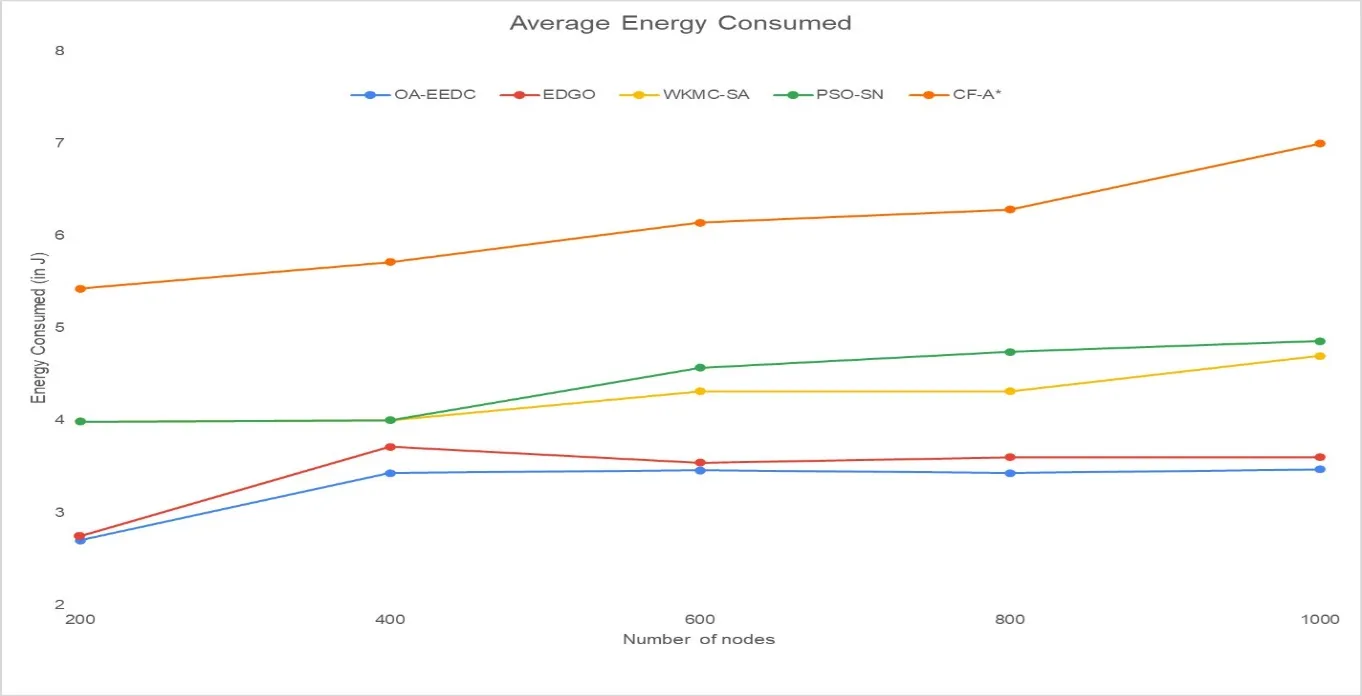
Fig. 18 Average Energy Consumption
Energy consumption and network stability It is the required performance analysis metric to ensure that proposed scheme is efficient. It is because the sensor nodes are energy-constraint device. FIG and FIG illustrate the average energy consumed by the network and network stability respectively. Network stability indicates the occurrence of first node dead event. The groups initially created in our approach are formed in distributed manner but in further rounds base station announces the GH role for each group after certain number of rounds based on threshold remaining energy limit. This limits the energy consumption rate of GHs and each member in the group gets chance to become GH during the entire network lifetime. Besides this, the UAV traverses through an optimally ordered RPs avoiding obstacles, due to which the energy consumption rate of UAV is also optimized. In totality, it is worth saying that the energy consumption of whole network is optimized. Thus, the suggested OA-CBEEDC system outperforms the other schemes in terms of network stability enhancement and conservation of energy by determining the optimal grouping and feasible path selection for the UAV, as demonstrated in Fig. 23 and Fig. 24.
Fig. 19 Network Stability Performance
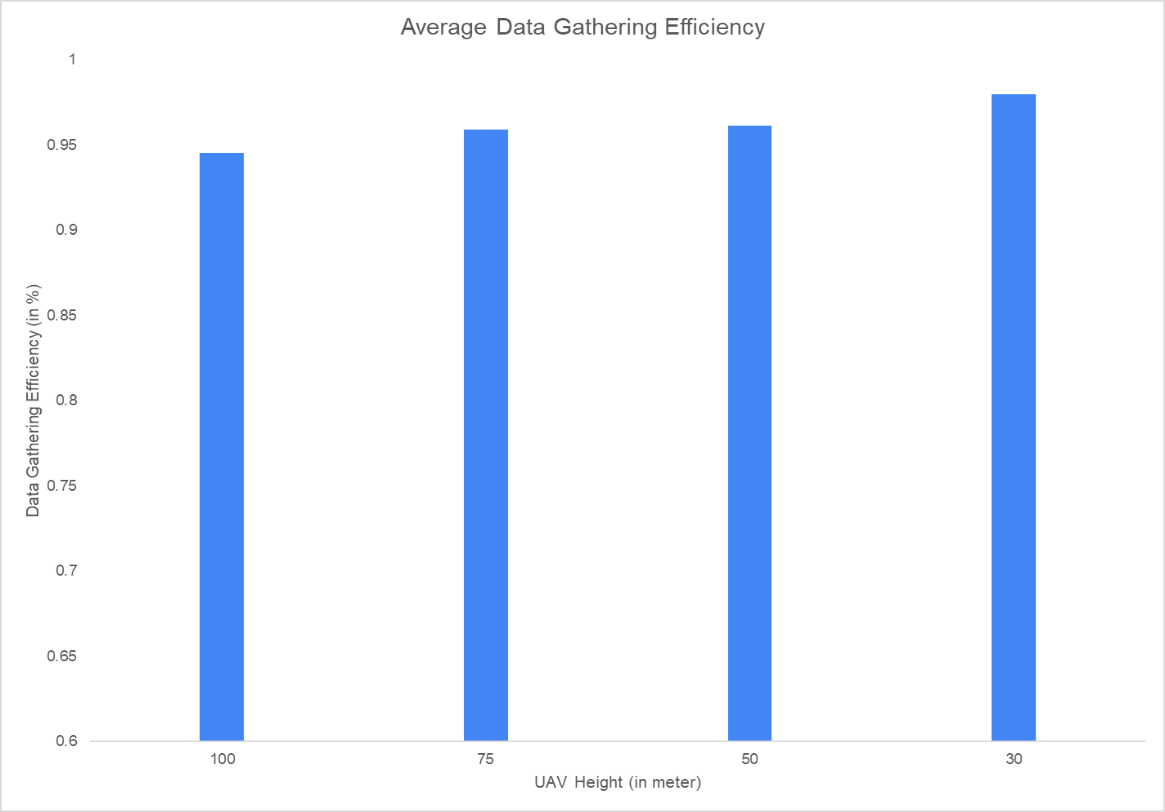
Fig. 20 Data Gathering Efficiency V/s Height of the UAV
Varying maximum UAV height In case of the obstacle-free region, the decrease in flying height increases the data collection efficiency and network lifetime. In contrast, obstacle-present scenario impacts the movement of UAV and as the UAV height is decreased the probability of hindrance due to obstacle increases. This in turn leads to increase in path length and data collection efficiency. Our proposed approach handles this situation also in optimal way. The substitution method and selection of obstacle-aware RPs helped in dealing with such situation. Fig 19 and Fig 20 show the data collection efficiency and UAV path length under varying maximum heights of UAV. The UAV in our case flies at fixed height because vertically up movement leads to more energy consumption. Hence, for different but fixed heights, our proposed approach showcases effective handling capability against the obstacles at reduced height of UAV also. At last, we present a performance summary of existing and proposed scheme in Table 2.
|
Algorithm |
Average Path Length (km) |
Average Flight Time (s) |
Average Energy Consumed (J) |
Network Stability (rounds) |
|
OA-CBEEDC |
3.67 |
869 |
3.27 |
2349 |
|
EDGO |
4.12 |
924 |
3.6 |
1821 |
|
WKMC-SA |
7.18 |
1487 |
4.7 |
1618 |
|
PSO-SN |
7.33 |
1435 |
4.85 |
1589 |
|
CF-A* |
18.12 |
3698 |
7 |
1010 |
Table 2 Algorithm comparison
CONCLUSION
We proposed a scheme in this work that uses UAVs to collect data from the terrestrial WSN with obstacles as an added constraint (OA-CBEEDC). An enhanced meta-heuristic algorithm is used to find the optimal trajectory for the UAV to fly and collect data from the effective rendezvous point (RPs). This obstacle-aware feasible UAV-path balances the energy consumption of nodes in the WSN and optimizes the delay of data delivery. The scheme minimizes node energy consumption by two methods, first by selecting group head and RP position in centralized and then by assisting group heads to relay data within communication range. Moreover, the optimal group head is selected on the basis of energy, number of neighbors and average distance of the neighbors. Further, the RPs are selected by simultaneously considering both obstacle and more than one group head at a time. The feasibility of the UAV path is also considered and infeasible path is substituted and regulated with desired number of deviation points. The result proves the efficacy of the OA-CBEEDC scheme against other counterpart schemes. The network stability improved significantly due to bet-ter grouping and RP selection. The data gathering efficiency of whole network also improved in case of both number of nodes and varying UAV height. Even though the performance of the proposed OA-CBEEDC is effective thereafter it has limitations. The grouping of nodes can be further improved by adopting obstacle-aware approach and by introducing WSN compatible optimization algorithms and by obstacle-aware. Hence, in future we will improve the network stability further by employing obstacle-aware optimal grouping and employ more than one UAV for performance enhancement in large WSN.
REFERENCES





Nilabh Kumar1*, Rupali Kumari1, Amit Kumar2, Nishant Bharti3, Smriti Bakshi4, Obstacle Aware Clustering-Based Energy Efficient Data Collection Scheme Using UAV Data Collector In Large Wireless Sensor Networks, Int. J. Sci. R. Tech., 2026, 3 (7), 1052-1080. https://doi.org/10.5281/zenodo.21698186
 10.5281/zenodo.21698186