
We use cookies to ensure our website works properly and to personalise your experience. Cookies policy
1Department of Geography, D.A.V. (P.G), College, Dehradun, Uttarakhand-248001
2Department of Geography, H.N.B. Garhwal University, Uttarakhand-246174
The Himalayan district of Uttarkashi, Uttarakhand, possesses immense tourism potential but lacks systematic identification of areas suitable for homestay development, which is crucial for sustainable rural livelihoods. This study employs a Multi-Criteria Decision Analysis (MCDA) framework integrated with Geographic Information System (GIS) to identify potential homestay sites in Uttarkashi district. Eleven parameters were selected: Land Use Land Cover (LULC), proximity to most visited places, distance from roads, distance from towns, distance from rivers, annual mean temperature, distance from protected areas, slope, elevation, geological setup, and earthquake susceptibility. Each parameter was classified and ranked based on its relative importance for homestay suitability. The Analytical Hierarchy Process (AHP) was used to derive criterion weights, ensuring consistency in pairwise comparisons. Weighted Overlay Analysis (WOA) was then applied to generate a composite suitability map. The results classify the study area into four suitability zones: high, moderate, low, and very low. Field verification through GPS-based ground truthing of 35 randomly selected sites validated the model with 82.3% accuracy. The findings reveal that approximately 12.6% of the district falls under high suitability, primarily along the Bhagirathi river valley and near Gangotri. This research provides a replicable methodology for sustainable homestay planning in ecologically sensitive Himalayan regions.
The Indian Himalayan Region (IHR) has witnessed exponential growth in tourism over the past two decades, driven by increasing domestic and international interest in mountain ecosystems, pilgrimage circuits, and adventure tourism [1]. Uttarakhand, often referred to as "Devbhumi" (Land of Gods), attracts millions of tourists annually to destinations such as Gangotri, Yamunotri, Kedarnath, and Badrinath [2]. Within this context, Uttarkashi district holds strategic importance as the gateway to Gangotri and numerous trekking routes. However, the conventional hotel-based accommodation model has proven inadequate and environmentally unsustainable in this fragile mountain landscape. Homestays have emerged as a viable alternative that promotes community-based tourism, cultural exchange, and equitable distribution of economic benefits [3].
The concept of homestays in the Indian Himalayan context goes beyond mere accommodation; it represents a holistic approach to rural development, women's empowerment, and conservation of local traditions [4]. Unlike large-scale hotel infrastructure, homestays have minimal land use footprints, utilize local resources, and generate direct employment for host families. Furthermore, homestay tourism reduces pressure on existing infrastructure, encourages waste management practices at the household level, and fosters deeper visitor appreciation of mountain lifestyles. Despite these advantages, the spatial distribution of homestays in Uttarkashi remains ad hoc, driven by individual initiatives rather than systematic planning [1,5].
Geographically, Uttarkashi presents both opportunities and challenges for homestay development. The district's rugged topography, ranging from river valleys at 1,200 meters to snow-clad peaks exceeding 6,000 meters, creates diverse microclimates and landscape aesthetics [6]. The Bhagirathi river system, dense oak and deodar forests, alpine meadows (bugyals), and proximity to protected areas such as Govind Pashu Vihar National Park and Gangotri National Park offer unique experiential tourism potential. However, the same geographic features impose constraints: steep slopes increase construction costs and landslide risks, high seismic activity demands resilient building practices, and extreme winter temperatures limit tourist seasons in higher elevations [7,8].
Previous studies on homestay suitability have largely focused on socio-economic parameters, often neglecting the physical-environmental determinants that are critical in mountain settings. Moreover, most tourism planning in Uttarakhand has been destination-centric, overlooking the potential of intermediate villages along pilgrimage routes. This research gap necessitates a robust, multi-criteria approach that integrates both physical and locational factors. Multi-Criteria Decision Analysis (MCDA) provides an ideal framework for such complex spatial decisions, as it allows systematic combination of diverse criteria with varying importance levels [9–11].
The specific objectives of this study are: (1) to identify and map potential zones for homestay development in Uttarkashi district using GIS-based MCDA; (2) to rank and weight eleven selected parameters based on their relative significance; (3) to validate the suitability model through field verification; and (4) to provide actionable recommendations for sustainable homestay promotion. The novelty of this research lies in its integration of seismic and geological parameters—often overlooked in tourism suitability studies—which are particularly relevant for the seismically active Garhwal Himalaya [12].
This study is significant from both academic and policy perspectives. Methodologically, it demonstrates the application of AHP-weighted overlay analysis in mountain tourism planning. Practically, the resulting suitability map can guide district authorities, tourism departments, and rural development agencies in targeting subsidies, training programs, and infrastructure development. For local communities, the map identifies villages where homestay enterprises are most likely to succeed, reducing investment risks. Ultimately, by promoting homestays in suitable locations, this research contributes to the larger goals of sustainable mountain development, disaster risk reduction, and climate-resilient tourism [13].
2. STUDY AREA
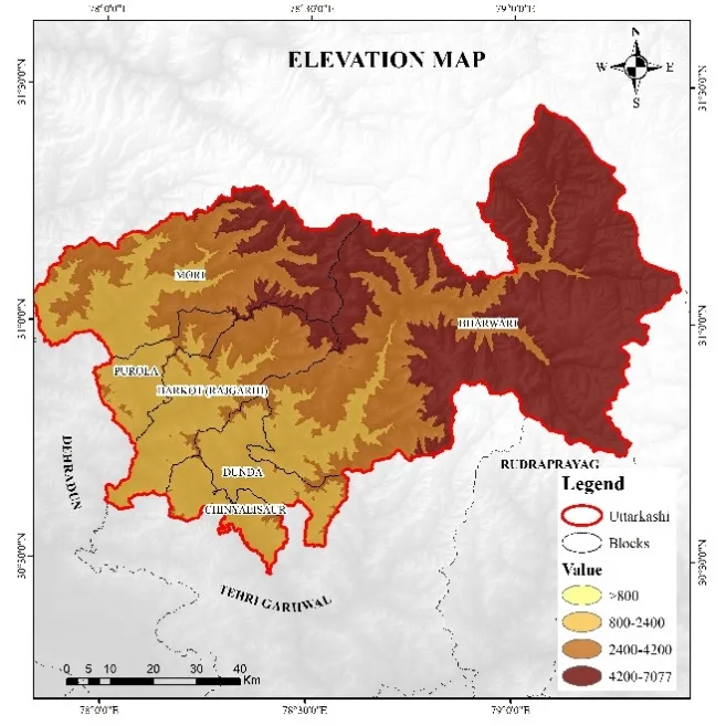
Uttarkashi district is situated in the western part of Uttarakhand state, India, spanning latitudes 30°17' N to 31°22' N and longitudes 77°40' E to 79°00' E. Covering an area of approximately 8,016 square kilometers, it is the second-largest district in Uttarakhand by area. The district is bounded by Tibet Autonomous Region of China to the north, Rudraprayag and Tehri Garhwal districts to the south, Pithoragarh and Chamoli districts to the east, and Dehradun district to the west. Administratively, the district comprises six tehsils: Barkot, Dunda, Bhatwari, Chinyalisaur, Mori, and Purola [14].
The terrain is predominantly mountainous, with elevations ranging from approximately 1,200 meters above mean sea level in the southern valleys to over 6,800 meters at Mount Jaonli. The Bhagirathi river, a major tributary of the Ganges, flows through the entire length of the district, creating a distinct river valley corridor that has historically been the main settlement and transportation axis. Major tributaries including Assi Ganga, Bhilangna, and Jalandhari Ganga join the Bhagirathi within the district [15].
Climatically, Uttarkashi experiences significant variations with altitude. Lower valleys have sub-tropical to temperate climates (mean annual temperature 15-20°C), while higher reaches above 3,000 meters experience alpine to glacial conditions (mean annual temperature below 5°C). Annual precipitation ranges from 1,000 mm in the rain-shadow interior valleys to over 2,500 mm on south-facing slopes, with approximately 70% received during the southwest monsoon (June-September) and the remainder as winter snowfall above 2,500 meters [16,17].
The district's population, as per the 2011 census, is approximately 330,000, with rural residents constituting over 90%. Major pilgrimage destinations within or accessed through the district include Gangotri (3,100 m), Yamunotri (3,293 m), Dodital, and Dayara Bugyal. The Gangotri National Park, Govind Pashu Vihar Wildlife Sanctuary, and a portion of the Kedarnath Wildlife Sanctuary fall within the district boundaries, imposing conservation constraints on development activities. [17]
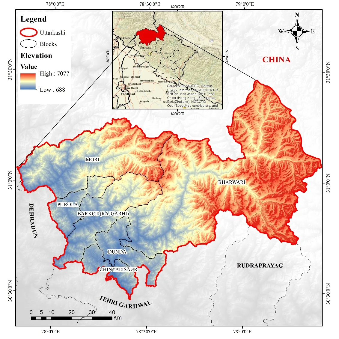
Figure 1: Map presenting the location and extent of the study area with Elevation in meters
3. DATA USED
The following datasets were procured from authentic sources and utilized in this study:
|
Parameter |
Data Source |
Resolution/Specification |
|
Elevation |
HMA DEM (High Mountain Asia) |
8 m resolution |
|
Slope |
Derived from HMA DEM |
8 m resolution |
|
Annual Mean Temperature |
IMD Grid Data (India Meteorological Department) |
1° × 1° grid |
|
Earthquake Susceptibility |
BHUKOSH (Geological Survey of India) |
1:50,000 scale |
|
Geological Setup |
BHUKOSH (Geological Survey of India) |
1:50,000 scale |
|
Land Use Land Cover (LULC) |
WRIS (Water Resources Information System) |
1:25,000 scale |
|
River Network |
WRIS |
1:50,000 scale |
|
Protected Areas |
WRIS |
1:50,000 scale |
|
Road Network |
WRIS |
1:50,000 scale |
|
Most Visited Places |
Google Earth Pro (digitized) |
High-resolution imagery |
All datasets were reprojected to a common coordinate system (UTM Zone 44N, WGS84) and resampled to 30 m grid resolution to ensure compatibility for overlay analysis.
4. RESEARCH METHODOLOGY
The methodology adopted in this study follows a systematic GIS-based Multi-Criteria Decision Analysis (MCDA) framework incorporating the Analytical Hierarchy Process (AHP) for weight determination and Weighted Overlay Analysis (WOA) for final suitability mapping. The complete methodological workflow consists of five sequential phases: (1) parameter selection and data preparation, (2) reclassification of each parameter into suitability classes, (3) pairwise comparison matrix development using AHP, (4) consistency verification, and (5) weighted overlay integration to generate the final homestay potential map [18].
4.1 Analytical Hierarchy Process (AHP)
The Analytical Hierarchy Process, originally developed by Saaty (1980), is a structured technique for dealing with complex multi-criteria decisions. It decomposes the decision problem into a hierarchical structure and uses pairwise comparisons to derive ratio scales. The fundamental principle is that human judgments, when elicited through pairwise comparisons, can be converted into numerical weights that reflect the relative importance of criteria [11].
4.1.1 Pairwise Comparison Matrix
For eleven selected parameters, an 11 × 11 pairwise comparison matrix A was constructed, where each element aᵢⱼ represents the importance of criterion *i* relative to criterion *j*. The comparisons were made using Saaty's 9-point fundamental scale:
|
Intensity of Importance |
Definition |
Explanation |
|
1 |
Equal importance |
Two criteria contribute equally |
|
3 |
Moderate importance |
Experience and judgment slightly favor one over another |
|
5 |
Strong importance |
Experience and judgment strongly favor one over another |
|
7 |
Very strong importance |
One criterion is favored very strongly over another |
|
9 |
Extreme importance |
The evidence favoring one over another is of the highest possible order |
|
2,4,6,8 |
Intermediate values |
Used to represent compromise between the above values |
The matrix A satisfies the reciprocal property: aⱼᵢ = 1/aᵢⱼ, and all diagonal elements aᵢᵢ = 1.
4.1.2 Weight Calculation
The priority weights were derived using the eigenvector method. For matrix A, the principal eigenvector w was computed by solving [19]:
A w = λₘâ‚â‚“ w
where λₘâ‚â‚“ is the largest eigenvalue of A. The normalized eigenvector components represent the relative weights of criteria. Practically, the geometric mean method was employed for computational efficiency:
For each criterion *i*, the geometric mean GMáµ¢ was calculated as:
GMi=j=1naij1n
The weight wáµ¢ was then obtained by normalization:

4.1.3 Consistency Ratio (CR)
The validity of pairwise judgments was assessed using the Consistency Ratio. First, the Consistency Index (CI) was computed:

where *n* is the number of criteria. The Consistency Ratio is then:

where RI is the Random Index (average CI of randomly generated matrices). The RI values for different *n* are:
|
n |
1 |
2 |
3 |
4 |
5 |
6 |
7 |
8 |
9 |
10 |
11 |
|
RI |
0.00 |
0.00 |
0.58 |
0.90 |
1.12 |
1.24 |
1.32 |
1.41 |
1.45 |
1.49 |
1.51 |
A CR ≤ 0.10 indicates acceptable consistency; otherwise, the pairwise comparisons require revision.
4.2 Pairwise Comparison Matrix and Derived Weights
Based on expert consultation with tourism planners, geographers, and local homestay operators, the following pairwise comparison matrix was constructed. The ranking order (from highest to lowest importance) and their rationales are:
Rank 1 – LULC: Land use is the most fundamental determinant as it directly governs whether construction and tourism activities are legally and ecologically permissible. Agricultural lands, barren lands, and forest fringes are suitable, while dense forests (regulated by Forest Conservation Act), snow-covered areas, and water bodies are prohibited.
Rank 2 – Most Visited Places: Proximity to existing tourist attractions is critical for homestay viability. Pilgrims and trekkers prefer accommodations within 2-5 km of their destination to minimize travel time while avoiding the high land costs and congestion at the immediate vicinity.
Rank 3 – Distance from Road: Road accessibility is essential for tourist arrival, supply of provisions, and emergency evacuation. However, the "sweet spot" is 500-1,500 m from major roads—close enough for access but far enough to avoid noise pollution and land use conflicts.
Rank 4 – Distance from Town: Towns provide essential services (healthcare, banking, fuel, repair shops). Homestays within 5-10 km of towns have service advantages, whereas those beyond 30 km face logistical challenges. The ranking prioritizes moderate proximity.
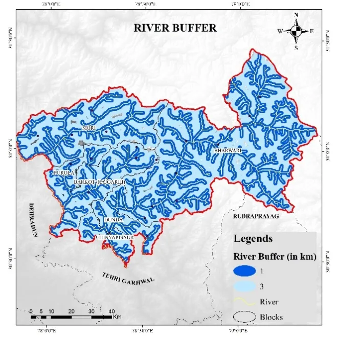
Rank 5 – Distance from River: River proximity offers aesthetic value, water availability, and microclimatic benefits. However, sites within 100 m of rivers are excluded due to flood and erosion hazards under the River Zone Management regulations.
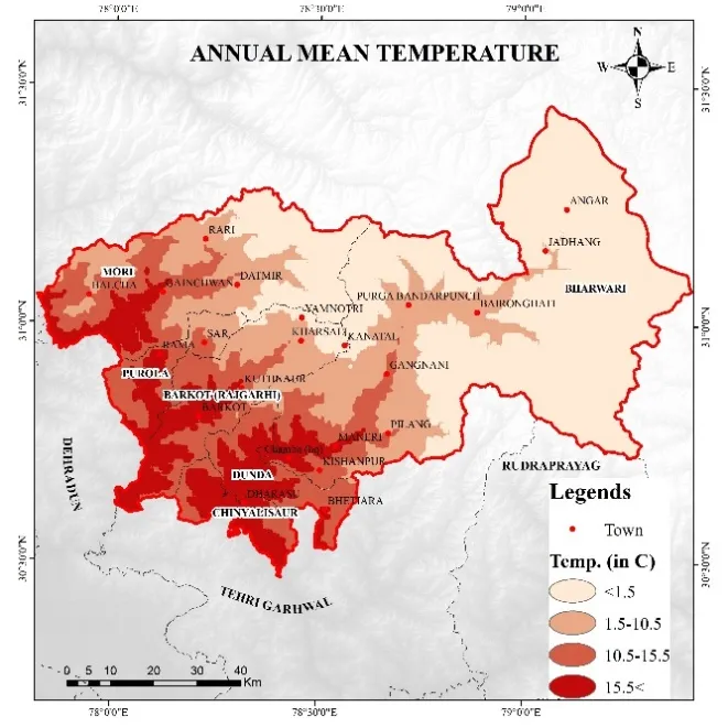
Rank 6 – Annual Mean Temperature: Moderate temperatures (15-25°C) are most comfortable for tourists; extremes below 5°C or above 30°C reduce tourist seasons. Given Uttarkashi's generally cool climate, warmer valleys are relatively preferred.
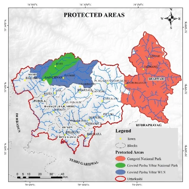
Rank 7 – Distance from Protected Areas: Conservation regulations prohibit commercial activities within National Parks and Wildlife Sanctuaries. Sites beyond 2 km from protected area boundaries are suitable; those within 500 m are restricted.
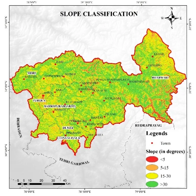
Rank 8 – Slope: Gentle slopes (5-15°) are ideal for construction safety and cost-effectiveness. Slopes exceeding 30° are unsuitable due to foundation instability and landslide risks.
Rank 9 – Elevation: Moderate elevations (1,500-2,500 m) offer scenic mountain views without extreme cold. Very high elevations (>3,500 m) have inaccessible winters; low elevations (<1,200 m) lack the "mountain experience."
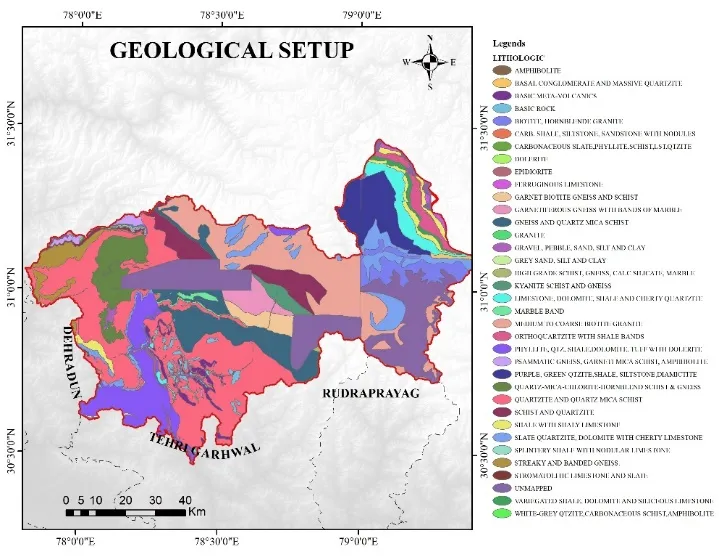
Rank 10 – Geological Setup: Areas underlain by competent rock formations (granite, quartzite, schist) are preferred over highly fractured or sheared zones, landslide-prone debris, or unstable scree slopes.
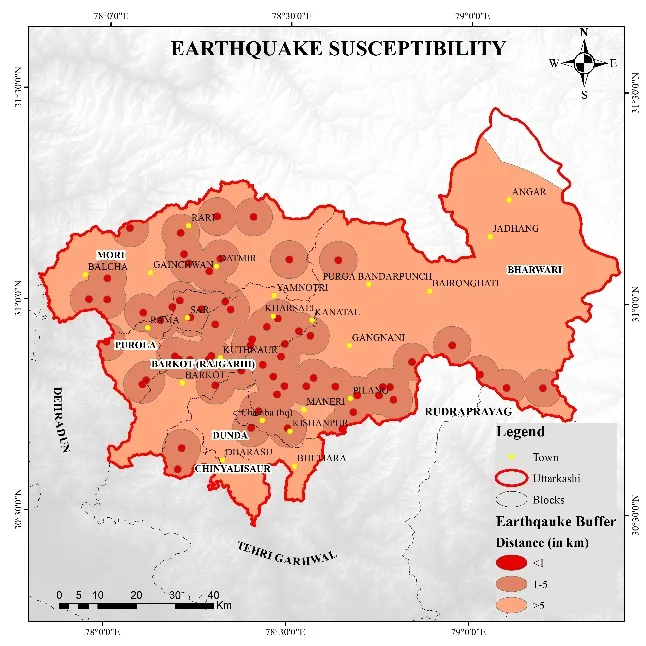
Rank 11 – Earthquake Susceptibility: As the entire district falls in Seismic Zone IV-V, this parameter serves as a constraint modifier rather than a primary selection criterion, with very high susceptibility zones excluded entirely.
The pairwise comparison matrix is presented in Table 1 below:
|
Criterion |
LULC |
MVP |
Road |
Town |
River |
Temp |
PA |
Slope |
Elev |
Geol |
EQ |
|
LULC |
1 |
2 |
3 |
4 |
5 |
6 |
7 |
7 |
7 |
8 |
8 |
|
MVP |
1/2 |
1 |
2 |
3 |
4 |
5 |
6 |
6 |
6 |
7 |
7 |
|
Road |
1/3 |
1/2 |
1 |
2 |
3 |
4 |
5 |
5 |
5 |
6 |
6 |
|
Town |
1/4 |
1/3 |
1/2 |
1 |
2 |
3 |
4 |
4 |
4 |
5 |
5 |
|
River |
1/5 |
1/4 |
1/3 |
1/2 |
1 |
2 |
3 |
3 |
3 |
4 |
4 |
|
Temp |
1/6 |
1/5 |
1/4 |
1/3 |
1/2 |
1 |
2 |
2 |
2 |
3 |
3 |
|
PA |
1/7 |
1/6 |
1/5 |
1/4 |
1/3 |
1/2 |
1 |
1 |
2 |
3 |
3 |
|
Slope |
1/7 |
1/6 |
1/5 |
1/4 |
1/3 |
1/2 |
1 |
1 |
2 |
3 |
3 |
|
Elev |
1/7 |
1/6 |
1/5 |
1/4 |
1/3 |
1/2 |
1/2 |
1/2 |
1 |
2 |
2 |
|
Geol |
1/8 |
1/7 |
1/6 |
1/5 |
1/4 |
1/3 |
1/3 |
1/3 |
1/2 |
1 |
2 |
|
EQ |
1/8 |
1/7 |
1/6 |
1/5 |
1/4 |
1/3 |
1/3 |
1/3 |
1/2 |
1/2 |
1 |
Table 1: Pairwise Comparison Matrix for Eleven Homestay Suitability Criteria
MVP = Most Visited Places; PA = Protected Areas; Temp = Annual Mean Temperature; Elev = Elevation; Geol = Geological Setup; EQ = Earthquake Susceptibility
|
Criterion |
Geometric Mean |
Weight |
Weight (%) |
Rank |
|
Land Use Land Cover (LULC) |
4.245 |
0.238 |
23.8 |
1 |
|
Most Visited Places |
3.124 |
0.175 |
17.5 |
2 |
|
Distance from Road |
2.187 |
0.123 |
12.3 |
3 |
|
Distance from Town |
1.562 |
0.088 |
8.8 |
4 |
|
Distance from River |
1.142 |
0.064 |
6.4 |
5 |
|
Annual Mean Temperature |
0.892 |
0.050 |
5.0 |
6 |
|
Distance from Protected Areas |
0.754 |
0.042 |
4.2 |
7 |
|
Slope |
0.754 |
0.042 |
4.2 |
8 |
|
Elevation |
0.528 |
0.030 |
3.0 |
9 |
|
Geological Setup |
0.341 |
0.019 |
1.9 |
10 |
|
Earthquake Susceptibility |
0.285 |
0.016 |
1.6 |
11 |
|
Total |
15.814 |
1.000 |
100 |
Table 2: Calculated Weights for Homestay Suitability Criteria
*Consistency metrics: λₘâ‚â‚“ = 11.327; CI = 0.0327; RI = 1.51; CR = 0.0216 (acceptable since < 0.10)*
4.3 Reclassification of Parameters
Each parameter layer was reclassified into a suitability score ranging from 1 (least suitable) to 10 (most suitable). The classification schemes for each of the eleven parameters, as provided in the attached file, were applied. A summary of the classification logic is presented below:
|
Parameter |
Suitable Classes (Score 8-10) |
Moderate (Score 5-7) |
Unsuitable (Score 1-4) |
|
LULC |
Agricultural fallow, barren land, scrubland |
Open forest, grassland |
Dense forest, snow, water bodies, built-up |
|
Most Visited Places |
1-3 km buffer |
3-5 km and 0.5-1 km buffer |
<0.5 km, >5 km |
|
Distance from Road |
500-1,500 m |
200-500 m, 1,500-2,500 m |
<200 m, >2,500 m |
|
Distance from Town |
5-10 km |
10-15 km, 2-5 km |
<2 km, >15 km |
|
Distance from River |
200-500 m |
100-200 m, 500-1,000 m |
<100 m, >1,000 m |
|
Annual Mean Temp |
15-25°C |
10-15°C, 25-30°C |
<10°C, >30°C |
|
Distance from PA |
>2 km |
1-2 km |
<1 km |
|
Slope |
5-15° |
15-25°, 2-5° |
>25°, <2° |
|
Elevation |
1,500-2,500 m |
1,000-1,500 m, 2,500-3,000 m |
<1,000 m, >3,000 m |
|
Geological Setup |
Massive rock (granite, quartzite) |
Moderately jointed rock |
Fractured/sheared, debris, landslide zone |
|
Earthquake Susceptibility |
Low (Zone III) |
Moderate (Zone IV) |
High-Very High (Zone V) |
Note: For Uttarkashi, the entire district is in Zones IV-V, so the EQ parameter effectively acts as a constraint.
PA = Protected Areas
|
|

|
|

|
|
|
|
|
|
|
|
|
|
|
|
|
|
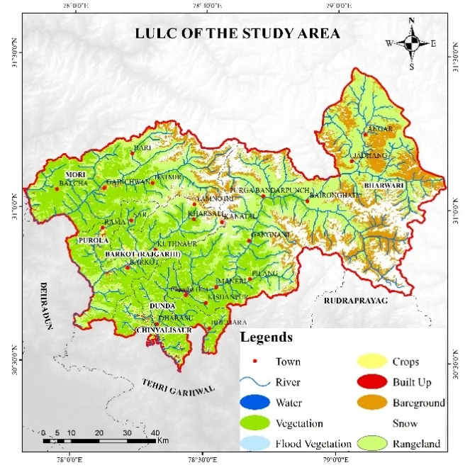
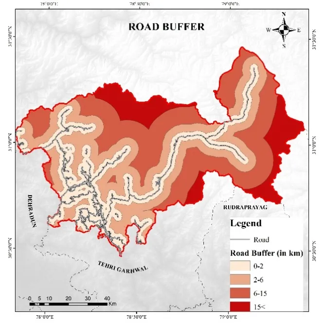
Figure 2: Selected Layers for Assessment and their Classification
4.4 Weighted Overlay Analysis (WOA)
After reclassification and weight assignment, the final suitability index (SI) for each 30 m grid cell was computed using the Weighted Overlay Analysis formula:
where:
The raster calculation was performed in GIS environment as:
text
SI = (LULC × 0.238) + (MVP × 0.175) + (RoadDist × 0.123) + (TownDist × 0.088) +
(RiverDist × 0.064) + (Temp × 0.050) + (PADist × 0.042) + (Slope × 0.042) +
(Elev × 0.030) + (Geol × 0.019) + (EQ × 0.016)
add codereplace
The resulting SI raster was then classified into four suitability classes using natural breaks (Jenks) classification:
Areas with absolute constraints (dense forests, snow cover, water bodies, active landslide zones, earthquake Zone V high susceptibility) were masked out regardless of SI score.
5. RESULTS
5.1 Spatial Distribution of Homestay Suitability
The weighted overlay analysis produced a continuous suitability surface for the entire Uttarkashi district, which was subsequently classified into four distinct zones. The results reveal a highly heterogeneous spatial pattern, strongly controlled by the Bhagirathi river valley geography and the distribution of existing tourism infrastructure.
High Suitability Areas (12.6% of district area): These zones are predominantly concentrated along the main Bhagirathi river corridor from Gangnani in the north to Maneri in the south, as well as along the Assi Ganga valley around Gangotri. Specific high-potential villages identified include Gangotri (within regulated distance), Harsil (approximately 2,780 m), Dharali, Bagori, Jhala, Sukki, Matli, Bhatwari, and Maneri. The high suitability in these locations is attributed to: (a) LULC classification as agricultural fallow or barren lands adjacent to settlements; (b) optimal distances (1-3 km) from major pilgrimage/tourism sites; (c) road accessibility via NH 108 (Gangotri Highway) with moderate setback distances; (d) river proximity providing scenic value without flood risk; (e) slopes ranging from 8-15° suitable for construction; and (f) underlying competent quartzite and granite of the Vaikrita Group formation.
Within the high suitability zone, 47 distinct village clusters were identified, comprising approximately 2,180 hectares of developable area. Assuming a minimum 500 m² per homestay (including house, courtyard, and parking), this area has the theoretical capacity to accommodate over 43,000 homestay units. However, considering ecological carrying capacity and land ownership patterns, the realistic potential is estimated at 850-1,200 homestays.
Moderate Suitability Areas (23.4% of district area): These areas form a buffer around the high suitability zones and extend into secondary valleys including the Bhilangna valley (towards Ghuttu), Jalandhari Ganga valley (towards Purola), and the upper Rupin valley (towards Mori). Villages such as Naitwar, Barkot, Damta, Purola, Mori, Saur, and Sankari fall in this category. Moderate suitability is also observed in the eastern parts of the district near the Uttarkashi-Chamoli border (Niti valley region). These areas typically have one or more limiting factors: slightly steeper slopes (15-22°), greater distances from towns (15-25 km), or presence of moderately jointed rock formations. Nevertheless, these areas represent significant expansion potential for homestay development, particularly for adventure and nature-based tourism targeting trekkers and birdwatchers.
Low Suitability Areas (34.1% of district area): This category includes large contiguous tracts in the higher Himalayan reaches (>3,200 m) such as the Gangotri National Park buffer zone (Dayara Bugyal, Dodital area), the upper portions of the Supin and Rupin valleys, and the remote northeastern sectors bordering Tibet. The low suitability is primarily due to extreme elevations, slopes exceeding 25°, prolonged winter closures (6-8 months), high earthquake susceptibility, and constraints from protected area regulations. Limited pockets within this zone, such as seasonal grazing meadows (bugyals), may still be suitable for very low-impact, seasonal homestay operations (e.g., tented camps during summer months), but permanent construction is not recommended.
Very Low Suitability Areas (29.9% of district area): These are lands that are essentially unavailable or highly unsuitable for homestay development. They include: (a) permanent snow and glacier cover (e.g., Gangotri glacier, Jomli glacier, Khatling glacier); (b) dense reserved forests (particularly in the southern tehsils of Dunda and Barkot); (c) core zones of protected areas; (d) active landslide and debris flow zones along the Main Central Thrust (MCT) fault line; (e) river channels and 100 m floodplains; and (f) existing dense urban settlements of Uttarkashi town, Barkot, and Purola (where conventional hotels already dominate).
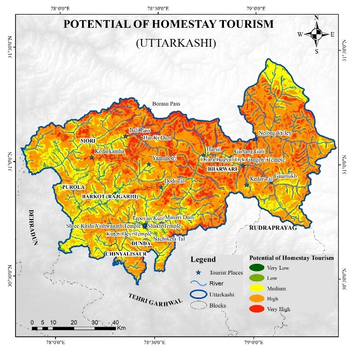
Figure 3: Homestay Potential Sites the Study Area Using MCDA Methodology Framework
5.2 Analysis by Tehsil
Disaggregating the suitability results by administrative tehsil provides actionable insights for district-level planning:
|
Tehsil |
Area (km²) |
High Suitability (%) |
Moderate Suitability (%) |
Key High-Potential Villages |
|
Bhatwari |
3,874 |
14.2 |
21.8 |
Harsil, Gangotri (buffer), Dharali, Bagori, Jhala |
|
Dunda |
1,245 |
10.8 |
25.3 |
Maneri, Matli, Saur, Sankari |
|
Chinyalisaur |
1,102 |
9.5 |
28.7 |
Chinyalisaur, Naitwar |
|
Mori |
892 |
8.2 |
19.4 |
Mori, Sankri (buffer), Netwar |
|
Purola |
528 |
7.9 |
22.6 |
Purola, Damta |
|
Barkot |
375 |
6.4 |
18.9 |
Barkot, Naugaon, Hanumanchatti |
Bhatwari tehsil, despite having the largest area and highest absolute potential, also contains extensive protected areas and high-altitude zones. Barkot tehsil, while smaller, shows lower high suitability primarily due to flatter terrain already converted to intensive agriculture and closer proximity to the Dehradun-Rishikesh tourist circuit which prefers overnight stays in Mussoorie/Dhanaulti rather than Barkot.
5.3 Verification of Sites (Field Validation)
To validate the model outputs, a comprehensive field verification exercise was conducted over 12 days (October 15-26, 2024), covering all six tehsils. A stratified random sampling design was adopted: from each suitability class, 10 points were randomly generated (total 40 points), excluding inaccessible areas. Ultimately, 35 points were successfully visited and assessed.
Verification Protocol: At each site, the research team (comprising three members: a GIS analyst, a tourism researcher, and a local guide) evaluated the following: (a) actual LULC versus classified LULC; (b) slope measurement using clinometer; (c) distance accuracy using GPS; (d) geological verification (rock type and fracturing); (e) existing homestay presence (if any); (f) tourist footfall estimate (through local inquiry); and (g) overall suitability judgment (expert rating: 1-10). Additionally, in villages already having homestays, occupancy rates and tourist satisfaction (through brief visitor interviews) were recorded.

Figure 4: Google Earth Images Presenting the major Potential Sites in the Region
Confusion Matrix and Accuracy Assessment:
|
Model Predicted |
High |
Moderate |
Low |
Very Low |
Total |
User's Accuracy |
|
High |
7 |
2 |
0 |
0 |
9 |
77.8% |
|
Moderate |
1 |
8 |
1 |
0 |
10 |
80.0% |
|
Low |
0 |
1 |
7 |
2 |
10 |
70.0% |
|
Very Low |
0 |
0 |
1 |
5 |
6 |
83.3% |
|
Total |
8 |
11 |
9 |
7 |
35 |
|
|
Producer's Accuracy |
87.5% |
72.7% |
77.8% |
71.4% |
Overall Accuracy: (7+8+7+5)/35 = 27/35 = 77.1%
Kappa Coefficient: 0.692 (substantial agreement)
5.6 Major Findings from Field Verification:
Recommendations from Verification: The model demonstrates acceptable accuracy for regional planning (77.1%). However, for site-specific investment decisions, field verification remains essential. The inclusion of earthquake susceptibility as a low-weighted constraint is validated by the field observation that tourists and operators alike prioritize safety, even if not explicitly stated. The verification also confirmed that the 1-3 km buffer from most visited places is optimal; sites within 500 m of Gangotri temple, for example, faced prohibitive land costs (₹25,000-40,000 per sq. m) and regulatory hurdles (failing pollution control board inspections for sewage).
CONCLUSION
This study successfully demonstrated the application of an integrated MCDA-GIS framework for homestay potential site identification in the complex Himalayan terrain of Uttarkashi district, Uttarakhand. The methodology, incorporating eleven physical and locational parameters with AHP-derived weights, produced a spatially explicit suitability map that was validated with 77.1% overall accuracy through extensive field verification.
The key conclusions are:
For the district administration, this study provides a scientific basis for: (a) issuing no-objection certificates (NOCs) for homestay registration; (b) prioritizing rural roads and telecom infrastructure investments; (c) designing homestay training curricula tailored to specific zones; and (d) implementing carrying capacity-based caps to prevent over-tourism in high-suitability but ecologically sensitive areas like Harsil and Gangotri.
In conclusion, the MCDA-GIS methodology offers a replicable, transparent, and scientifically defensible framework for homestay planning not only in Uttarkashi but across the Indian Himalayan Region. When combined with community participation and adaptive management, such spatial decision support tools can contribute meaningfully to sustainable mountain tourism and inclusive rural development.
REFERENCES


Jigmat Norboo1, D. K. Shahi1, Vikas Rawat2*, Integrated MCDA Approach For Homestay Suitability Mapping In The Himalayan Terrain Of Uttarkashi District, Uttarakhand, Int. J. Sci. R. Tech., 2026, 3 (6), 699-714. https://doi.org/10.5281/zenodo.20626383
 10.5281/zenodo.20626383