

We use cookies to ensure our website works properly and to personalise your experience. Cookies policy
1B.Arch. 4th year, Amity University, Lucknow
2Department of architecture & planning , Amity University Lucknow
Sarnath, located approximately 10 km northeast of Varanasi, is one of the most significant Buddhist pilgrimage destinations in the world. It is the place where Lord Buddha delivered his first sermon after attaining enlightenment, making it an invaluable cultural and archaeological landscape. While its monuments, including Dhamek Stupa and Chaukhandi Stupa, have received considerable conservation attention, the surrounding ecological landscape has often remained underexplored. This study investigates the changes in tree canopy within the Sarnath heritage zone using Green Mapping techniques. By analyzing historical and contemporary satellite imagery, the research evaluates whether the region has experienced a net loss or gain of vegetation over recent decades. Furthermore, the study examines the contrasting spatial characteristics of Dhamek Stupa and Chaukhandi Stupa and proposes an integrated pedestrian green corridor connecting the two monuments. Such a corridor would strengthen ecological continuity, improve visitor experience, reduce vehicular dependency, and reinforce Sarnath's identity as both a cultural and environmental heritage landscape.
1. Background of the Study
The relationship between cultural heritage and the natural environment has become increasingly significant in contemporary urban planning and landscape conservation. Historic settlements are not merely collections of monuments; they are dynamic cultural landscapes where built heritage, vegetation, water systems, biodiversity, and human activities have evolved together over centuries. Trees, gardens, open spaces, and ecological corridors contribute as much to the identity and sustainability of heritage sites as the monuments themselves. As cities continue to expand under the pressures of population growth, tourism, and infrastructure development, many historic landscapes are experiencing rapid changes in land use, often resulting in the fragmentation or disappearance of natural vegetation. These transformations not only affect environmental quality but also alter the visual, cultural, and spiritual character of heritage places.
2. Research Problem
Although Sarnath remains one of the most important Buddhist pilgrimage destinations in the world, current conservation efforts have primarily focused on the protection of monuments rather than the wider landscape that supports them. Fragmentation of tree cover due to urban expansion, road development, commercial activities, and increasing tourist infrastructure has gradually altered the environmental character of the heritage precinct. At the same time, the absence of a safe, shaded, and continuous pedestrian route between Chaukhandi Stupa and Dhamek Stupa limits opportunities for visitors to experience the historical sequence of Buddha's journey through the landscape. This study addresses these interconnected environmental and spatial challenges by examining changes in tree canopy and proposing an integrated green corridor that supports both ecological restoration and heritage interpretation.
3. Aim
The aim of this research is to evaluate the loss and gain of tree canopy within the Sarnath heritage landscape using Green Mapping techniques and to develop a sustainable pedestrian green corridor that strengthens ecological connectivity, enhances visitor experience, and reconnects Dhamek Stupa with Chaukhandi Stupa as a unified cultural landscape.
II. SCOPE OF THE STUDY
The study focuses on selected heritage precincts of Sarnath and examines the relationship between tree canopy, land use, built-up areas, transportation networks, open spaces, and pedestrian movement.
The study specifically considers:
The study primarily relies on satellite imagery, GIS-based analysis, field observations, and available secondary information, with emphasis on spatial analysis and planning recommendations.
III. STUDY AREA
1. Location
The study area is located in Sarnath, approximately 10 kilometres northeast of Varanasi city in the state of Uttar Pradesh, India. Geographically, Sarnath lies at approximately 25.381° N latitude and 83.022° E longitude and forms an important part of the Varanasi metropolitan region. The site is situated on relatively flat alluvial plains of the Middle Ganga Basin, at an average elevation of about 80–82 metres above mean sea level. Its level topography and fertile alluvial soil have historically supported the growth of native vegetation and extensive tree cover.
Sarnath is one of the most significant Buddhist pilgrimage centres in the world and is internationally recognized as the place where Lord Buddha delivered his first sermon
(Dhammacakkappavattana Sutta) after attaining enlightenment at Bodh Gaya. This event marked the beginning of the Buddhist Sangha, making Sarnath a site of immense religious, archaeological, historical, and cultural importance. Today, the area attracts thousands of domestic and international visitors every year, making it one of the major heritage tourism destinations in northern India.
The study primarily focuses on two prominent archaeological monuments within the Sarnath heritage precinct: Dhamek Stupa and Chaukhandi Stupa. These two monuments represent contrasting landscape settings and provide an ideal basis for analysing variations in tree-canopy distribution and environmental conditions.
The Dhamek Stupa is situated within the protected archaeological park, surrounded by landscaped gardens, lawns, mature trees, monasteries, museums, and pedestrian pathways. Due to continuous maintenance by heritage authorities, this precinct retains a relatively dense tree canopy and extensive green spaces, creating a comfortable microclimate and an attractive setting for visitors.
In contrast, the Chaukhandi Stupa is located approximately 1.5 kilometres southwest of Dhamek
Stupa, near the main approach road to Sarnath. Unlike the enclosed archaeological park, the Chaukhandi precinct is more exposed to vehicular traffic, roadside commercial activities, parking areas, and urban development. Consequently, vegetation around the monument is comparatively sparse and fragmented, resulting in greater solar exposure and reduced pedestrian comfort.
The study area encompasses not only the monuments themselves but also their surrounding landscape, including archaeological gardens, open spaces, roads, parking areas, religious institutions, commercial establishments, and residential neighbourhoods. This broader landscape context is essential because tree-canopy change is influenced not only by natural ecological processes but also by land-use patterns, tourism infrastructure, transportation networks, and urban expansion.
From a climatic perspective, Sarnath experiences a humid subtropical climate, characterized by hot summers, a monsoon season, and cool winters. Summer temperatures often exceed 40°C, while winter temperatures may fall below 10°C. The average annual rainfall is approximately 1,000–1,100 mm, received mainly during the southwest monsoon. These climatic conditions highlight the importance of tree canopy in providing shade, reducing surface temperatures, improving air quality, enhancing rainwater infiltration, and creating thermally comfortable outdoor environments for visitors.
The strategic location of Sarnath within the rapidly growing Varanasi urban region makes it an important case study for examining the interaction between heritage conservation, urban development, and environmental sustainability. Analysing the loss or gain of tree canopy around Dhamek Stupa and Chaukhandi Stupa provides valuable insights into how green infrastructure can support the long-term preservation of cultural landscapes while improving ecological resilience and visitor experience.
METHODOLOGY
The study adopts a spatial and environmental assessment approach to understand tree canopy conditions in Sarnath.
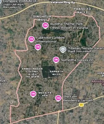
Step 1 – Identification of Study Area
The major heritage precincts and surrounding urban areas were identified,
with particular attention to Dhamek Stupa and Chaukhandi Stupa. FIG. 3. (SOURCE – GOOGLE MAP)
Step 2 – Land-Use Analysis
The study area was examined according to major land-use categories, including archaeological areas, green/open spaces, religious buildings, commercial areas, residential settlements, roads, and parking.
Step 3 – Temporal Tree Canopy Assessment
Tree canopy conditions were comparatively assessed for three time periods:
2005 → 2015 → 2025
Step 4 – Environmental Assessment
The relationship between tree canopy and:
Step 5 – Comparative Assessment
Dhamek Stupa and Chaukhandi Stupa were compared based on tree density, shade, landscape quality, heat exposure, biodiversity, pedestrian comfort, and urban pressure.
Step 6 – SWOT Analysis
Strengths, weaknesses, opportunities, and threats were identified for both heritage precincts.
Step 7 – Recommendations
Landscape and green infrastructure strategies were developed based on the observed environmental challenges.
V. LAND-USE ANALYSIS
The study identifies seven major land-use categories within the Sarnath study area.
Land Use Approx. Share Characteristics
| Archaeological Zone 35% | Protected monuments |
|---|---|
| Green/Open Spaces 28% | Gardens, lawns and tree cover |
| Residential 12% | Peripheral settlements |
| Religious Buildings 10% | Temples and monasteries |
| Commercial 8% | Shops and restaurants |
| Roads/Parking 7% | Tourist access and parking |
The archaeological zone and green/open spaces together form a significant proportion of the study landscape. However, commercial development and road infrastructure are increasingly concentrated along peripheral areas, where canopy reduction and fragmentation are more evident.
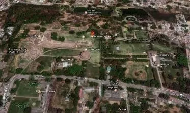
FIG. 5.1 (SOURCE –STALLITE IMAGE)
VI. FACTORS CONTRIBUTING TO TREE CANOPY GAIN OR LOSS
1. Gain of tree canopy
Several factors have supported vegetation growth and maintenance in Sarnath:
These interventions have particularly benefited the archaeological core, where mature trees and landscaped gardens contribute to a continuous green environment.
2. Loss of tree canopy
Tree canopy reduction and fragmentation are associated with:
These activities can reduce available planting areas and fragment existing ecological corridors, particularly along the urban fringe.
VII. COMPARATIVE ANALYSIS
1. Dhamek Stupa
Historical Importance
Constructed around the 5th–6th century CE over earlier Mauryan foundations, Dhamek Stupa marks the location where Buddha delivered his first sermon (Dhammacakkappavattana Sutta). It remains the spiritual core of Sarnath and an active pilgrimage destination.
Architectural Characteristics
Existing Green Environment
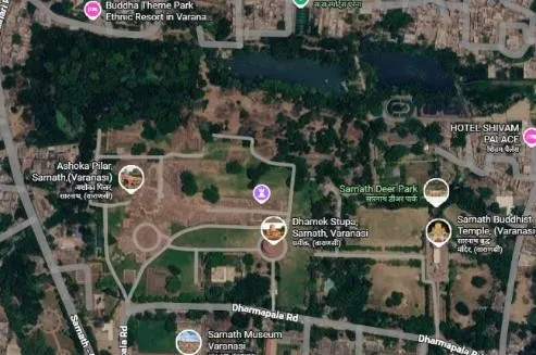
FIG.7.1 (SOURCE- GOOGLE MAP)
The green environment significantly enhances the monument's visual dominance and thermal comfort.
2. Chaukhandi Stupa
Historical Importance
Chaukhandi Stupa commemorates the meeting of Lord Buddha with his first five disciples before the first sermon at Sarnath.
The existing octagonal Mughal tower was added during the reign of Emperor Akbar in memory of Humayun's visit.
Architectural Characteristics
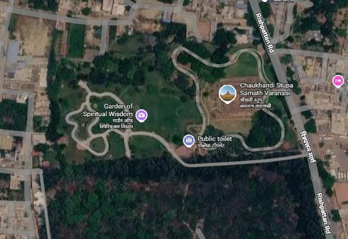
FIG. 7.2 (SOURCE- GOOGLE MAP)
VIII. Proposal: Green Heritage Pedestrian Corridor
A continuous pedestrian spine connecting Chaukhandi Stupa and Dhamek Stupa is proposed.
1. Concept
"Walk Through Buddha's Journey."
Instead of isolated monument visits, tourists experience the historical sequence through a shaded landscape.
Major Design Components
2. Suggested Native Plantation Recommended species include:
These species provide shade, biodiversity benefits, and cultural relevance to Buddhist landscapes.
CONCLUSION
Green Mapping demonstrates that Sarnath is not merely a collection of monuments but a living cultural landscape where ecological systems and heritage values are inseparable. While protected precincts such as Dhamek Stupa retain healthy tree cover, surrounding areas face increasing pressure from urbanization, resulting in fragmented canopy and weakened ecological continuity.
The proposed green pedestrian corridor linking Chaukhandi Stupa and Dhamek Stupa addresses these challenges by integrating heritage conservation with landscape restoration. Shaded walkways, native tree plantations, sustainable drainage, and interpretive public spaces would reconnect the two monuments in a way that reflects Buddha's historical journey while improving visitor comfort and environmental quality.
Future planning in Sarnath should therefore move beyond monument-centric conservation toward a holistic landscape approach in which trees, open spaces, pedestrian networks, and archaeological heritage are conserved as one interconnected system. Such an approach will preserve the site's Outstanding Universal Value while creating a resilient, inclusive, and ecologically rich heritage destination for future generations.
REFERENCES


Sonal Yadav, Ar. Madhavendra Pratap Singh, Green Mapping: Loss or Gain of Tree Canopy in Sarnath Heritage Zone - Integrating Landscape Conservation with Heritage Tourism Through Pedestrian Connectivity, Int. J. Sci. R. Tech., 2026, 3 (10), 1180-1185. https://doi.org/10.5281/zenodo.23645739
 10.5281/zenodo.23645739