

We use cookies to ensure our website works properly and to personalise your experience. Cookies policy
Department of Geography, Hemwati Nandan Bahuguna Garhwal University (A Central University), Srinagar Garhwal, Uttarakhand- 246174
Srinagar, the historic capital of the Garhwal region in Uttarakhand, represents a unique confluence of cultural heritage, market dynamics, and environmental challenges in the Himalayan landscape. This study examines the geo-cultural attributes and market geography of Srinagar Nagar Nigam through a comprehensive questionnaire survey of 67 respondents (31 shopkeepers and 36 residents) across 40 municipal wards. The research investigates four interconnected dimensions: cultural perceptions including festival celebrations and linguistic trends, environmental consciousness regarding the Alaknanda River and climate change, market geography encompassing business composition and consumer behaviour, and urban infrastructure challenges. Key findings reveal that 78% of respondents believe Garhwali speakers have increased, while 68% perceive decreased Alaknanda River discharge following dam construction, with 100% reporting river pollution and temperature rise. The study identifies Dhari Devi Temple as the most significant historical-religious site, and traffic congestion, rough tourist driving, and livelihood concerns as the predominant urban issues. The research contributes to understanding the complex interplay between cultural resilience, environmental degradation, and market dynamics in a medium-sized Himalayan urban centre, offering insights for sustainable urban planning in ecologically sensitive mountain regions.
The Himalayan region of Uttarakhand represents one of India's most ecologically sensitive and culturally rich landscapes. Within this mountainous terrain, Srinagar—situated on the banks of the Alaknanda River in the Pauri Garhwal district—holds a position of historical, cultural, and economic significance. As the ancient capital of the Garhwal kingdom, Srinagar has evolved from a medieval political centre into a contemporary administrative, educational, and commercial hub serving the broader Garhwal region. The town's transformation over centuries reflects the broader patterns of Himalayan urbanization, where traditional socio-cultural structures intersect with modern economic pressures and environmental challenges.
The geographical significance of Srinagar is rooted in its strategic location within the Alaknanda Valley, positioned at approximately 30°13′N latitude and 78°47′E longitude, at an elevation of 560 metres above sea level. This valley setting has historically facilitated trade, cultural exchange, and political administration, making Srinagar a nodal point in the Garhwal Himalayas. The town's 40 municipal wards, extending from the tourism-influenced areas near Dhari Devi Temple (Ward 1) to the more urbanized central wards (Wards 14-20), exhibit considerable spatial variation in terms of economic activity, cultural practices, and environmental conditions.
Understanding the geo-cultural dimensions of Srinagar requires examining how the physical landscape has shaped and been shaped by human activities. The Alaknanda River, a major tributary of the Ganges, has been both a lifeline and a source of vulnerability for the region's inhabitants. Recent decades have witnessed significant anthropogenic interventions, including dam construction and hydropower development, which have fundamentally altered the river's discharge patterns and ecological health. The Srinagar Hydroelectric Project (SHEP) exemplifies the tension between developmental imperatives and environmental sustainability that characterizes many Himalayan river systems.
Cultural geography forms another critical dimension of this study. The Garhwal region possesses a distinct cultural identity, expressed through language, festivals, religious practices, and historical consciousness. The Garhwali language serves as a marker of regional identity, with 78% of respondents in this study perceiving an increase in Garhwali speakers—a finding that challenges assumptions about language decline in Himalayan regions. Festivals such as Diwali, Holi, Baikund Chaturdashi Mela, and Eid reflect the syncretic cultural fabric of Srinagar, where Hindu and Muslim communities have coexisted for centuries.
The market geography of Srinagar reveals the economic pulse of the region. With a population of approximately 20,115 according to the 2011 Census, Srinagar functions as the primary market centre for the surrounding hill areas. The town hosts a diverse range of commercial establishments, including fruit vendors, general stores, restaurants, mobile shops, and garment shops, many of which have operated for over fifteen years. The weekly market visits by 67% of respondents underscore the town's role as a periodic market centre serving both urban and rural populations.
However, Srinagar's urban development has not been without challenges. Traffic congestion, drinking water availability, rough driving by tourists, and livelihood concerns emerge as critical urban issues affecting residents' quality of life. The narrow road infrastructure, particularly in the older wards, constrains mobility and creates friction between local residents and the seasonal tourist influx. The 100% respondent agreement on temperature increase over the past two decades, accompanied by the installation of air conditioners in 40% of households, signals the tangible impacts of climate change in this Himalayan urban centre.
This study adopts an integrated geographical approach to examine the interconnections between cultural practices, market dynamics, environmental perceptions, and urban challenges in Srinagar Nagar Nigam. By analysing primary data collected through structured questionnaires from 67 respondents across the town's 40 wards, the research aims to contribute empirical insights into the geo-cultural and market geography of this important Himalayan urban centre. The findings have implications for understanding the broader processes of urbanization, cultural change, and environmental transformation in the Indian Himalayan region.
2. STUDY AREA
Srinagar Nagar Nigam is located in the Pauri Garhwal district of Uttarakhand, India, situated along the banks of the Alaknanda River in the Garhwal Himalaya. The town lies between the latitudes of 29°40′ to 31°5′30′′ N and longitudes of 77°51′30′′ to 80°30′′ E, within the broader Garhwal region that encompasses approximately 29,089 square kilometres. The Srinagar Valley exhibits a distinctive geomorphology characterized by eight levels of river terraces and five levels of debris flow surfaces, reflecting the complex interplay of tectonic activity and fluvial processes.
Administratively, Srinagar is divided into 40 municipal wards, each with its unique demographic and economic characteristics. The ward structure ranges from Ward 1 near Dhari Devi Temple, which experiences maximum tourism influence, to Wards 14-20 in the major city core, where narrow roads and traffic constraints limit tourist movement. The town's elevation at 560 metres above sea level places it in the sub-montane zone of the Himalayas, characterized by a subtropical to temperate climate.
As per the 2011 Census, Srinagar had a population of 20,115, with males constituting 52% and females 48% of the population. The town functions as a significant administrative and educational hub, hosting the Birla Campus of Hemwati Nandan Bahuguna Garhwal University, a central university established in 1973. The population is predominantly Hindu (approximately 96%), with Muslim, Sikh, Buddhist, and Christian minorities. Hindi and Pahari (including Garhwali) are the primary languages spoken in the town.
The Alaknanda River serves as the principal drainage system, flowing through the Srinagar Valley and providing water for domestic, agricultural, and industrial purposes. The river's channel pattern in the Srinagar Valley exhibits significant tectonic influence, including abrupt changes in flow direction, incised meandering, and offset river channels. The construction of the Srinagar Hydroelectric Project has substantially altered the river's hydrological regime, with implications for both the environment and local livelihoods.
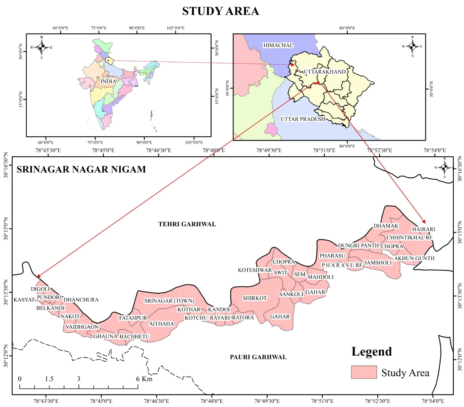
Figure 1: Location and Extent of Study Area with Village-wise Distribution
3. RESEARCH METHODOLOGY
3.1 Research Design
This study employs a mixed-methods research design combining quantitative survey methods with qualitative observations to investigate the geo-cultural and market geography of Srinagar Nagar Nigam. The research follows a cross-sectional design, capturing data at a single point in time to understand the current state of cultural perceptions, market dynamics, environmental awareness, and urban challenges. The study adopts a geographical approach that integrates physical geography (environmental perceptions, river ecology), human geography (cultural practices, market geography), and urban geography (infrastructure, mobility) within a unified analytical framework.
3.2 Sampling Strategy
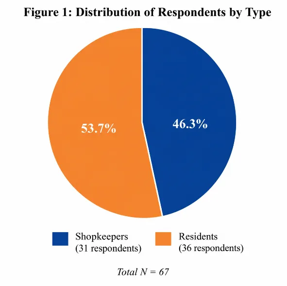
The sampling framework for this study was constructed using a stratified purposive sampling strategy to ensure representation across the 40 municipal wards of Srinagar Nagar Nigam. The total sample comprised 67 respondents, including 31 shopkeepers and 36 residents, selected from wards spanning the entire geographical extent of the municipal area. The stratification was based on two primary criteria:
Zone Classification: The 40 wards were categorized into two zones based on tourism influence. Zone 1 (High Tourism Influence) comprised Wards 1-13, particularly the areas near Dhari Devi Temple, which experience maximum tourist footfall. Zone 2 (Low Tourism Influence) comprised Wards 14-40, representing the major city core where narrow roads and traffic constraints limit tourist movement. This zonation allowed for comparative analysis of tourism's impact on cultural and market geography.
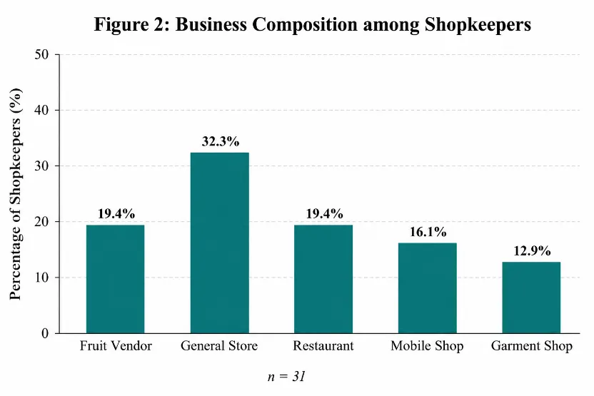
Respondent Type: Two categories of respondents were identified: shopkeepers (n=31) and residents (n=36). Shopkeepers were further stratified by business type, including fruit vendors (6), general stores (10), restaurants (6), mobile shops (5), and garment shops (4). This stratification ensured representation across the diverse commercial landscape of Srinagar.
3.3 Data Collection Instruments
Questionnaire Design: A structured questionnaire was developed comprising four thematic sections:
Section 1: Demographic and Business Information – Captured respondent type, ward number, business type (for shopkeepers), years in business, gender, age group, education level, and market visit frequency.
Section 2: Cultural and Festival Perceptions – Assessed the importance of major festivals (Diwali, Holi, Baikund Chaturdashi Mela, Eid) using a four-point Likert scale (1=Not Important to 4=Very Important). This section also captured perceptions of Garhwali language trends and the importance of historical-religious places (Dhari Devi Temple, Kamleshwar Temple, Devalgarh, Sitlamata, Gurudwara, Masjid).
Section 3: Environmental Perceptions – Addressed perceptions of Alaknanda River discharge change (increased/same/decreased), river pollution level, temperature change over the past two decades, AC installation status, and the decline of specific medicinal plants (Lalten, Giloi, Timla, Teddu, Ashoka Tree, Neem).
Section 4: Urban Issues and Tourism Influence – Assessed the severity of urban issues (traffic, drinking water availability, rough driving by tourists, source of income) using a four-point scale (1=Not an Issue to 4=Major Issue), and perceived tourism influence on a five-point scale (1=Very Low to 5=Very High).
Data Collection Procedure: The questionnaire was administered through face-to-face interviews conducted between [specify period] across the 40 wards. Respondents were approached at their places of business (for shopkeepers) or residences (for residents). Each interview lasted approximately 20-25 minutes. Informed consent was obtained from all participants, and confidentiality of responses was assured.
|
|
|
Figure 2: Total Number of Respondents and Variables
3.4 Data Analysis
The collected data were entered into a spreadsheet and analysed using descriptive and inferential statistical techniques:
Descriptive Statistics: Frequencies and percentages were calculated for all categorical variables to summarize respondent characteristics, cultural perceptions, environmental views, and urban issue assessments. These formed the basis of the results presented in this paper.
Cross-tabulation Analysis: Relationships between variables (e.g., zone type vs. tourism influence perception, respondent type vs. festival importance) were examined using cross-tabulation to identify patterns and differences across respondent categories.
Comparative Analysis: Responses were compared between shopkeepers and residents, and between high-tourism and low-tourism zones, to understand spatial and occupational variations in perceptions.
3.5 Ethical Considerations
This research adhered to ethical guidelines for social science research. Participation was voluntary, and respondents were informed about the purpose of the study. All data were anonymized, and individual responses were aggregated for analysis. The research did not involve any sensitive personal information beyond the scope of the study objectives.
3.6 Limitations
The study has several limitations that should be acknowledged. First, the sample size of 67 respondents, while adequate for exploratory analysis, limits the generalizability of findings to the entire population of Srinagar. Second, the cross-sectional design captures perceptions at a single point in time and cannot establish causal relationships. Third, the reliance on self-reported perceptions may introduce response bias. Fourth, the study focuses on Srinagar Nagar Nigam and may not be representative of other Himalayan urban centres. Despite these limitations, the research provides valuable empirical insights into the geo-cultural and market geography of this important Himalayan town.
4. RESULTS
4.1 Respondent Demographics and Business Profile
The study sample comprised 67 respondents, of which 31 (46.3%) were shopkeepers and 36 (53.7%) were residents (Table 1). Among shopkeepers, the distribution across business types revealed general stores as the most common (32.3%), followed by fruit vendors and restaurants (each 19.4%), mobile shops (16.1%), and garment shops (12.9%) (Table 2). Business longevity analysis showed that 58% of shopkeepers had been operating for more than 15 years, indicating a stable and established commercial sector (Table 3).
|
Respondent Type |
Frequency (n) |
Percentage (%) |
|
Shopkeepers |
31 |
46.3% |
|
Residents |
36 |
53.7% |
|
Total |
67 |
100% |
Table 1: Distribution of Respondents by Type
|
Business Type |
Frequency (n) |
Percentage (%) |
|
Fruit Vendor |
6 |
19.4% |
|
General Store |
10 |
32.3% |
|
Restaurant |
6 |
19.4% |
|
Mobile Shop |
5 |
16.1% |
|
Garment Shop |
4 |
12.9% |
|
Total |
31 |
100% |
Table 2: Business Composition among Shopkeepers
|
Years in Operation |
Frequency (n) |
Percentage (%) |
|
Less than 5 years |
3 |
9.7% |
|
5 – 10 years |
4 |
12.9% |
|
11 – 15 years |
6 |
19.4% |
|
More than 15 years |
18 |
58.0% |
|
Total |
31 |
100% |
Table 3: Business Longevity of Shopkeepers
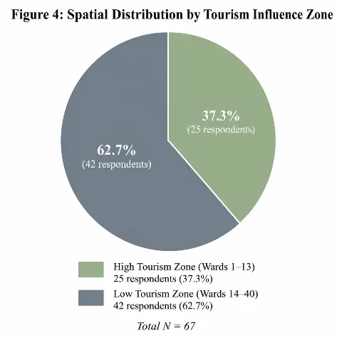
Spatial analysis based on ward location revealed that 37.3% of respondents (n=25) resided in or operated businesses in the high tourism influence zone (Wards 1-13), while 62.7% (n=42) were located in the low tourism influence zone (Wards 14-40) (Table 4).
|
Zone Type |
Wards Covered |
Frequency (n) |
Percentage (%) |
|
High Tourism Influence |
Ward 1 to 13 |
25 |
37.3% |
|
Low Tourism Influence |
Ward 14 to 40 |
42 |
62.7% |
|
Total |
67 |
100% |
Table 4: Spatial Distribution by Tourism Influence Zone
4.2 Market Geography and Consumer Behaviour
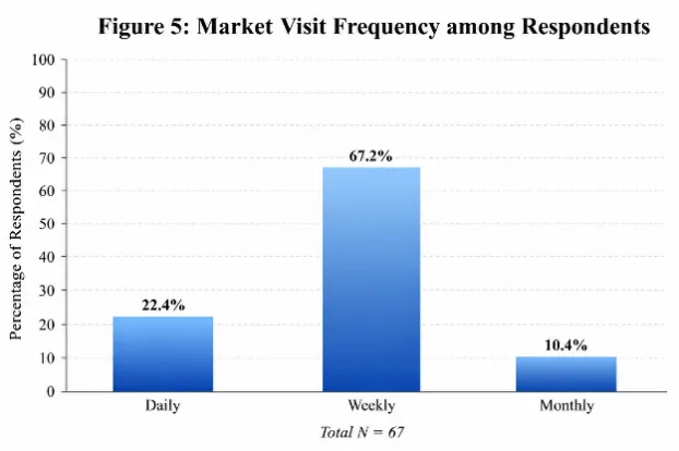
Analysis of market visit frequency revealed that the majority of respondents (67.2%, n=45) visited the Srinagar market on a weekly basis, while 22.4% (n=15) visited daily and 10.4% (n=7) visited monthly (Table 5). This pattern suggests that Srinagar functions primarily as a periodic market centre serving both urban residents and the surrounding rural population.
|
Visit Frequency |
Frequency (n) |
Percentage (%) |
|
Daily |
15 |
22.4% |
|
Weekly |
45 |
67.2% |
|
Monthly |
7 |
10.4% |
|
Rarely |
0 |
0% |
|
Total |
67 |
100% |
Table 5: Market Visit Frequency among Respondents
4.3 Cultural and Festival Perceptions
The analysis of festival importance revealed that Diwali was considered "Very Important" by 94% of respondents (n=63), followed by Holi at 86.6% (n=58) (Table 6). Baikund Chaturdashi Mela, a locally significant festival, was rated as "Very Important" by 59.7% (n=40) and "Important" by 40.3% (n=27). Eid was perceived as "Important" by 59.7% (n=40) and "Somewhat Important" by 40.3% (n=27), reflecting the town's religious diversity.
|
Festival |
Response Level |
Frequency (n) |
Percentage (%) |
|
Diwali |
Very Important |
63 |
94.0% |
|
Important |
4 |
6.0% |
|
|
Holi |
Very Important |
58 |
86.6% |
|
Important |
9 |
13.4% |
|
|
Baikund Chaturdashi Mela |
Very Important |
40 |
59.7% |
|
Important |
27 |
40.3% |
|
|
Eid |
Important |
40 |
59.7% |
|
Somewhat Important |
27 |
40.3% |
Table 6: Perceived Importance of Festivals
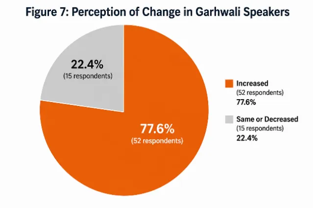
Regarding language perceptions, 77.6% (n=52) of respondents believed that Garhwali speakers had increased, while 22.4% (n=15) believed the number had remained the same or decreased (Table 7).
|
Response |
Frequency (n) |
Percentage (%) |
|
Increased |
52 |
77.6% |
|
Same / Decreased |
15 |
22.4% |
|
Total |
67 |
100% |
Table 7: Perception of Change in Garhwali Speakers
The importance of historical and religious places showed distinct patterns (Table 8). Dhari Devi Temple was rated as "Very Important" by all 67 respondents (100%). Kamleshwar Temple was rated "Very Important" by 80.6% (n=54) and "Important" by 19.4% (n=13). Devalgarh and Sitlamata were both rated as "Important" by all respondents (100%). Gurudwara and Masjid were rated as "Somewhat Important" by all respondents (100%), reflecting their significance to minority communities.
|
Historical Place |
Importance Level |
Frequency (n) |
Percentage (%) |
|
Dhari Devi Temple |
Very Important |
67 |
100% |
|
Kamleshwar Temple |
Very Important |
54 |
80.6% |
|
Important |
13 |
19.4% |
|
|
Devalgarh |
Important |
67 |
100% |
|
Sitla mata |
Important |
67 |
100% |
|
Gurudwara |
Somewhat Important |
67 |
100% |
|
Masjid |
Somewhat Important |
67 |
100% |
Table 8: Importance of Historical and Religious Places
4.4 Environmental Perceptions
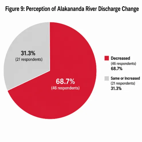
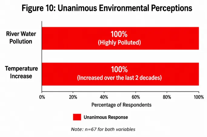
Environmental analysis revealed strong consensus among respondents on several indicators (Table 9). Regarding the Alaknanda River, 68.7% (n=46) believed that river discharge had decreased following dam construction, while 31.3% (n=21) perceived it as the same or increased. All 67 respondents (100%) reported that river water was "Highly Polluted." Similarly, 100% of respondents believed that temperature had increased over the past two decades. AC installation was reported by 40.3% (n=27) of households, while 59.7% (n=40) continued using fans only.
|
Environmental Indicator |
Response |
Frequency (n) |
Percentage (%) |
|
Alakananda River Discharge |
Decreased |
46 |
68.7% |
|
Same / Increased |
21 |
31.3% |
|
|
River Water Pollution |
Highly Polluted |
67 |
100% |
|
Temperature Change |
Increased |
67 |
100% |
|
AC Installation |
Installed |
27 |
40.3% |
|
Not Installed |
40 |
59.7% |
Table 9: Environmental Perceptions
Regarding medicinal plants, all 67 respondents (100%) reported that six plant species—Lalten, Giloi, Timla, Teddu, Ashoka Tree, and Neem—had decreased in recent years (Table 10).
|
Medicinal Plant |
Respondents Reporting "Decreased" |
Percentage (%) |
|
Lalten |
67 |
100% |
|
Giloi |
67 |
100% |
|
Timla |
67 |
100% |
|
Teddu |
67 |
100% |
|
Ashoka Tree |
67 |
100% |
|
Neem |
67 |
100% |
Table 10: Medicinal Plants Reported as Decreased
4.5 Urban Issues
Analysis of urban issues revealed that traffic congestion, rough driving by tourists, and source of income were rated as "Major Issues" by all 67 respondents (100%) (Table 11). Drinking water availability was rated as a "Moderate Issue" by all respondents (100%), indicating concern but not at the crisis level of the other issues.
|
Urban Issue |
Severity Level |
Frequency (n) |
Percentage (%) |
|
Traffic Congestion |
Major Issue |
67 |
100% |
|
Rough Driving by Tourists |
Major Issue |
67 |
100% |
|
Source of Income / Livelihood |
Major Issue |
67 |
100% |
|
Drinking Water Availability |
Moderate Issue |
67 |
100% |
Table 11: Perceived Severity of Urban Issues
|
a) Business Longevity of Shopkeepers. 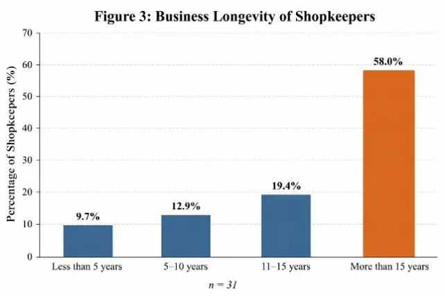
|
b) Spatial Distribution by Tourism Influence Zone
|
|
c) Market Visit Frequency among Respondents
|
d) Perception of Change in Garhwali Speakers
|
|
e) Perception of Alaknanda River Discharge Change
|
f) Unanimous Environmental Perception
|
Figure 3: Visual Representation of all the Responses
5. DISCUSSION
The findings of this study reveal a complex interplay between cultural resilience, environmental degradation, and urban challenges in Srinagar Nagar Nigam. The high percentage of respondents perceiving an increase in Garhwali speakers (78%) is noteworthy, as it challenges the narrative of language decline often associated with Himalayan regions. This perception may reflect a resurgence of regional identity consciousness, possibly driven by educational initiatives, cultural movements, or the presence of Garhwal University as a centre of regional language scholarship. The finding aligns with broader patterns of linguistic revitalization observed in other Himalayan regions, where local languages are being reclaimed as markers of cultural identity in the face of globalization.
The overwhelming importance attributed to Dhari Devi Temple (100% "Very Important") and other historical-religious sites underscores the deep-rooted spiritual geography of Srinagar. The temple's location near the Alaknanda River and its association with local folklore and pilgrimage circuits position it as a critical node in the region's cultural landscape. The recognition of both Hindu and Muslim sacred sites (Kamleshwar Temple, Gurudwara, Masjid) reflects the syncretic traditions of Garhwal, where communities have historically coexisted despite broader regional tensions.
The environmental perceptions documented in this study raise significant concerns about the sustainability of Srinagar's development trajectory. The 68% perception of decreased Alaknanda River discharge following dam construction corroborates scientific evidence of hydrological alterations caused by the Srinagar Hydroelectric Project. The 100% agreement on river pollution and temperature increase indicates widespread environmental awareness among residents, consistent with regional studies documenting urban heat island effects and declining water quality in the Alaknanda Valley.
The universal reporting of medicinal plant decline (100% for all six species) points to a significant loss of traditional knowledge and biodiversity. This finding aligns with broader research on medicinal plant depletion in the Garhwal Himalayas, attributed to over-exploitation, habitat loss, and changing land-use patterns. The decline of species such as Giloi (Tinospora cordifolia) and Neem (Azadirachta indica), which have important roles in traditional medicine, represents both an ecological and cultural loss.
The market geography analysis reveals Srinagar's character as a periodic market centre, with 67% of respondents visiting weekly. This pattern reflects the town's role as a service centre for the surrounding rural population, consistent with central place theory in mountain regions where accessibility constraints shape periodic market systems. The dominance of general stores (32%) and the longevity of businesses (58% operating >15 years) suggest a stable but potentially conservative commercial sector, vulnerable to changing consumer preferences and tourism patterns.
The urban issues identified—traffic congestion, rough tourist driving, and livelihood concerns—reflect the challenges of managing urban growth in a constrained Himalayan valley. The narrow road infrastructure, particularly in the older wards, creates friction between local mobility needs and tourist traffic, a common challenge in Himalayan hill stations. The 100% identification of income source as a major issue highlights the economic precarity faced by many residents, potentially exacerbated by seasonal tourism patterns and limited alternative employment opportunities.
|
|
|
|

|
|
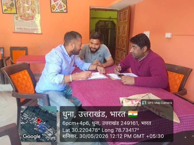
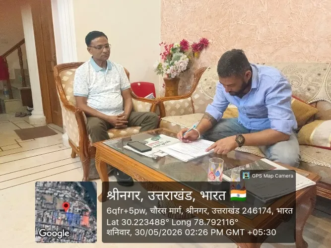
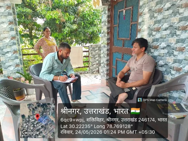
Figure 4: Glimpses of Intensive Field Survey
CONCLUSION
This geographical study of Srinagar Nagar Nigam reveals a Himalayan urban centre at a critical juncture, where cultural vitality coexists with environmental stress and urban challenges. The research demonstrates that Srinagar's geo-cultural identity remains robust, as evidenced by the strong attachment to historical-religious sites, the perceived resurgence of Garhwali language, and the continued celebration of diverse festivals. However, this cultural resilience is accompanied by significant environmental concerns, including river pollution, declining water discharge, temperature rise, and medicinal plant depletion—all of which threaten the long-term sustainability of the region.
The market geography of Srinagar reflects its historical role as a regional trade centre, with a stable commercial sector and periodic market rhythms serving both urban and rural populations. Yet this economic structure faces challenges from infrastructure constraints, seasonal tourism pressures, and livelihood insecurities that affect both shopkeepers and residents.
The findings underscore the need for integrated urban planning that addresses the interconnected dimensions of cultural preservation, environmental sustainability, and economic development. Specific recommendations emerging from this study include: (1) development of traffic management strategies that balance tourist mobility with local needs; (2) strengthening of drinking water infrastructure and watershed management; (3) documentation and conservation of medicinal plant species and traditional knowledge; (4) promotion of sustainable tourism practices that benefit local communities; and (5) support for Garhwali language and cultural institutions.
Future research should extend this analysis through longitudinal studies tracking environmental and cultural changes, comparative studies with other Himalayan urban centres, and deeper investigation of the relationship between tourism development and cultural change. As Srinagar continues to evolve in the context of regional development and climate change, understanding its geo-cultural and market geography becomes increasingly important for sustainable urban planning in the Himalayan region.
REFERENCES

Suraj Singh Bhandari*, M. S. Panwar, A Geographical Study Of Geo-Culture And Market Geography Of Srinagar Nagar Nigam, Uttarakhand, Int. J. Sci. R. Tech., 2026, 3 (7), 1127-1138. https://doi.org/10.5281/zenodo.21702440
 10.5281/zenodo.21702440