

We use cookies to ensure our website works properly and to personalise your experience. Cookies policy
Department Of Amity School Of Architecture And Planning, Lucknow Campus
Mehsaul Chowk is one of the busiest urban junctions located on Dumra Road in Sitamarhi district, Bihar. It serves as an important link between Sitamarhi town, the commercial center, and Dumra, the administrative headquarters. Due to its strategic location, the junction experiences heavy movement of vehicles, pedestrians, and commercial activities throughout the day. Over the years, the area has transformed from an agricultural settlement into a major commercial and transportation hub. This research paper analyzes the existing condition of Mehsaul Chowk by studying its land use, road network, traffic movement, infrastructure, environmental conditions, and urban character. Field observations indicate that rapid urban growth has increased commercial development but has also created serious problems such as traffic congestion, roadside parking, inadequate pedestrian facilities, poor drainage, noise pollution, and lack of green spaces. The nearby Railway Level Crossing (LC-56) further increases traffic delays during peak hours. The study uses site surveys and SWOT analysis to identify the strengths, weaknesses, opportunities, and threats of the junction. It also examines the impact of the ongoing Road Over Bridge (ROB) project, which is expected to improve traffic circulation and create opportunities for better public spaces. The research concludes that sustainable planning, improved infrastructure, better traffic management, and pedestrian-friendly design can transform Mehsaul Chowk into a safe, efficient, and environmentally friendly urban space while preserving its commercial importance.
Urban public spaces play a significant role in the physical, social, and economic development of a city. Major intersections are not only transportation nodes but also centres of commercial activities, public interaction, and urban growth. A well-planned junction improves mobility, accessibility, and environmental quality, whereas an unplanned junction often results in traffic congestion, poor pedestrian movement, inadequate infrastructure, and environmental degradation. Therefore, studying such urban spaces is essential for understanding existing conditions and proposing sustainable planning strategies.
Mehsaul Chowk is one of the most important transportation and commercial junctions located on Dumra Road in Sitamarhi district, Bihar. It serves as a major link between Sitamarhi town, the commercial centre of the district, and Dumra, the administrative headquarters. Because of this strategic location, the junction experiences continuous movement of people, vehicles, and commercial activities throughout the day. Thousands of commuters, students, government employees, traders, shoppers, and visitors use this route daily, making Mehsaul Chowk one of the busiest urban spaces in the district.
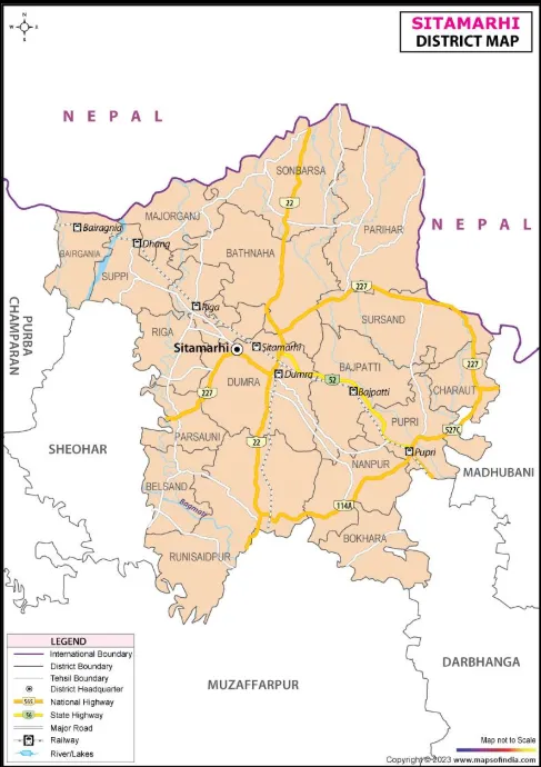
Fig 1. Map of Sitamarhi District (Source: Goggle)
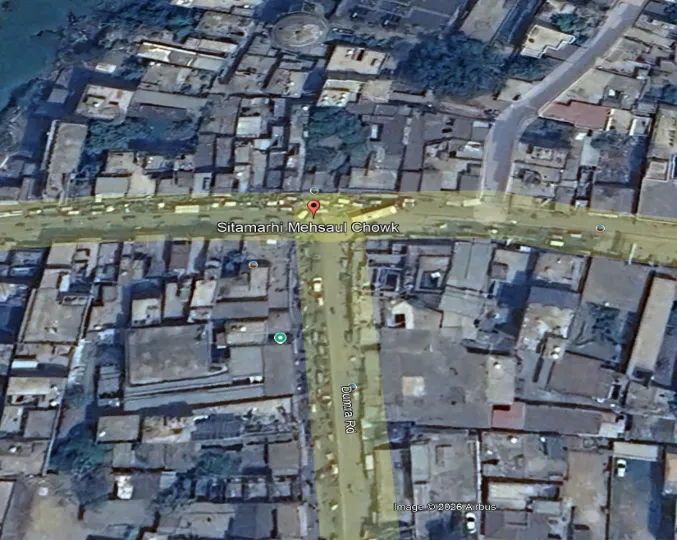
Fig.2 Location Of Mehsaul Chowk (Source: Goggle Earth)
The junction is situated near Kargil Chowk and Nahar Chowk, with an average road width of 18–24 metres. Unlike a planned four-way intersection, Mehsaul Chowk has an irregular three-way road configuration where the main Dumra Road intersects with several local roads, while the nearby railway line crosses the area in the east–west direction. This complex road pattern creates continuous interaction between regional traffic, local vehicles, pedestrians, and commercial activities. The presence of Railway Level Crossing No. 56 (LC-56) further affects traffic flow, resulting in long queues of vehicles and severe congestion whenever the railway gate remains closed.
The existing built environment around Mehsaul Chowk reflects unplanned but rapid urbanization. Most buildings along the main road are mixed-use developments, where the ground floors are occupied by commercial activities and the upper floors are used for offices, coaching centres, or residential purposes. Building heights generally vary between one and five storeys. However, most commercial buildings are constructed close to the road edge with little or no setback. Encroachments by roadside vendors, temporary structures, shop extensions, and on-street parking reduce the available road width and pedestrian space, creating congestion and affecting the quality of the urban environment.
Despite its growing commercial importance, Mehsaul Chowk faces several urban challenges. Heavy traffic congestion, inadequate pedestrian infrastructure, poor drainage, roadside encroachments, unorganized parking, noise pollution, dust, and the lack of green spaces reduce the overall quality of the public environment. During the monsoon season, blocked drainage systems often cause waterlogging, while increasing commercial development and continuous traffic movement contribute to environmental pollution and the urban heat island effect.
2. HISTORICAL DEVELOPMENT OF MEHSAUL CHOWK
The historical development of Mehsaul Chowk is closely associated with the growth of Sitamarhi district. Sitamarhi is widely recognized as the birthplace of Goddess Sita according to the Hindu epic Ramayana, giving the region great religious and cultural significance. The land surrounding Mehsaul Chowk was historically part of the ancient Mithila Kingdom and remained primarily agricultural for many centuries.
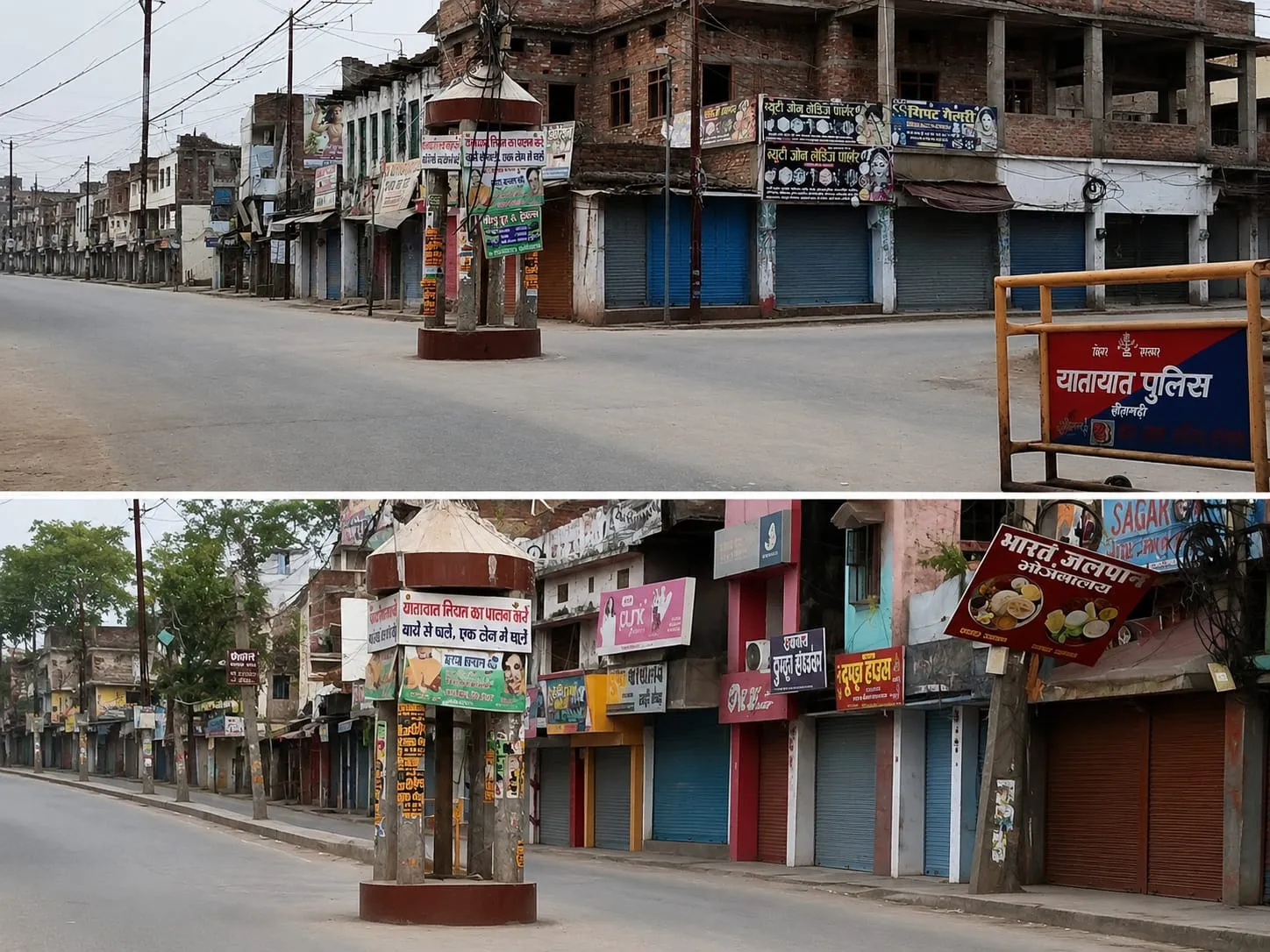
Fig 3. Mehsaul Chowk (Source : Author)
The modern development of the area began during the British colonial period. In 1875, Sitamarhi became a subdivision of Muzaffarpur district, while Dumra was selected as the administrative headquarters. Government offices, courts, and residential quarters were established in Dumra, whereas Sitamarhi continued to function as the commercial centre. To improve communication between these two important areas, a road was constructed, which later developed into the present-day Dumra Road. This road gradually encouraged settlement and commercial growth around Mehsaul.
The Bihar–Nepal Earthquake of 1934 marked another important stage in the region's development. The earthquake caused extensive damage to the old town, and reconstruction activities promoted urban expansion towards Dumra Road. As new residential and commercial developments emerged, the importance of Mehsaul gradually increased.
A major transformation occurred in 1972, when Sitamarhi became an independent district. The establishment of new government offices, educational institutions, and public facilities in Dumra generated a large volume of daily travel between Sitamarhi and Dumra. Because Mehsaul was located along this important route, it naturally developed into a major transportation and commercial junction.
During the late twentieth and early twenty-first centuries, rapid urbanization completely transformed the area. Agricultural land was converted into commercial developments, and small roadside shops gradually evolved into banks, showrooms, restaurants, hotels, coaching institutes, and service centres. Better road connectivity and increasing commercial activities attracted new investments, making Mehsaul Chowk one of the fastest-growing business districts in Sitamarhi.
3.TRAFFIC, CONNECTIVITY AND MOBILITY ANALYSIS OF MEHSAUL CHOWK
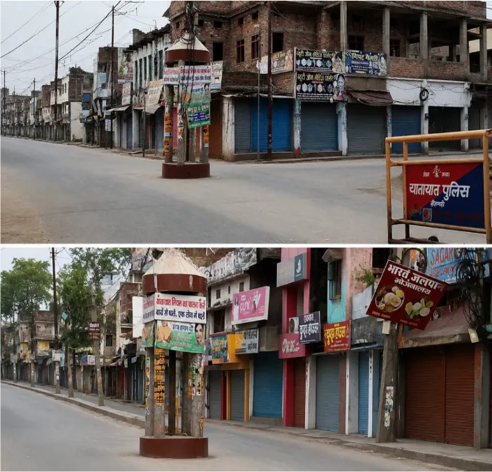
Fig 4. Road Of Mehsaul Chowk (Source: Author)
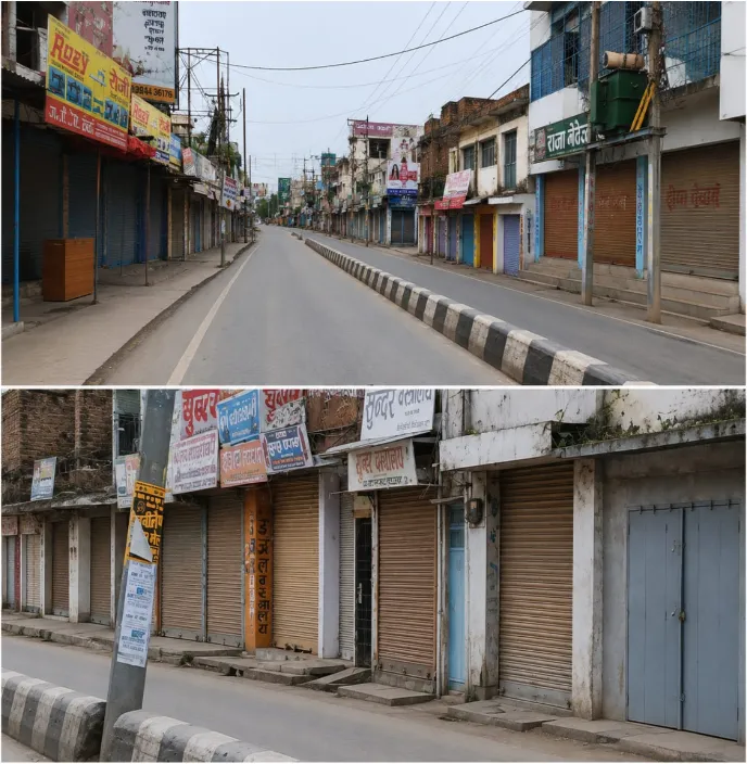
Fig 5. Connectivity Of Mehsaul Chowk (Source:Author)
The road network around Mehsaul Chowk consists of a primary arterial road (Dumra Road), secondary collector roads, and local residential streets.
The junction experiences a high volume of mixed traffic, including motorcycles, cars, buses, trucks, bicycles, auto-rickshaws, e-rickshaws, and pedestrians sharing the same road space. Two-wheelers and e-rickshaws form the largest share of daily traffic, while buses and commercial vehicles travelling towards nearby districts and the Indo–Nepal border further increase the traffic volume.
Mehsaul Chowk also functions as an important urban mobility hub because it provides easy access to markets, banks, educational institutions, hospitals, government offices, restaurants, and Sitamarhi Railway Station. Public transport services, including buses, auto-rickshaws, and e-rickshaws, ensure continuous local mobility and provide last-mile connectivity to nearby residential and commercial areas. However, the existing mobility system is affected by the absence of dedicated traffic lanes, organized parking spaces, traffic signals, and designated pick-up and drop-off zones. Frequent roadside parking and informal vending further reduce the effective carriageway width and slow down traffic movement.
Pedestrian mobility is another major concern at Mehsaul Chowk. Although thousands of people walk through the junction every day, the area lacks continuous footpaths, zebra crossings, pedestrian signals, and safe crossing facilities. As a result, pedestrians are forced to share the roadway with moving vehicles, increasing the risk of accidents and reducing overall road safety. Major conflict zones are observed near commercial frontages, informal e-rickshaw stands, roadside parking areas, and the railway crossing, where pedestrians and vehicles compete for limited road space.
The ongoing Road Over Bridge (ROB) project is expected to improve both traffic flow and urban mobility by separating through traffic from local traffic. After completion, the flyover will reduce congestion caused by the railway crossing, improve travel time, enhance pedestrian safety, and create opportunities for organized parking, dedicated pedestrian walkways, public transport facilities, and landscaped public spaces beneath the structure.
PEAK TRAFFIC HOURS
|
Time |
Traffic Condition |
Major Users |
|
9:00 AM – 11:30 AM |
High |
Students, Government Employees, Office Workers |
|
11:30 AM – 4:30 PM |
Moderate |
Local Commuters and Shoppers |
|
4:30 PM – 7:30 PM |
Very High |
Returning Office Workers, Visitors, Market Users |
|
After 8:00 PM |
Moderate |
Local Traffic |
Table 1. (Source: Author)
Traffic congestion increases significantly whenever Railway Level Crossing (LC-56) remains closed.
ESTIMATED TRAFFIC COMPOSITION
|
Vehicle Type |
Approximate Share |
|
Two-Wheelers |
40–45% |
|
E-Rickshaws / Auto-Rickshaws |
20–25% |
|
Cars & SUVs |
15–18% |
|
Buses |
5–7% |
|
Trucks & Commercial Vehicles |
6–8% |
|
Bicycles |
2–4% |
|
Pedestrian Movement |
Very High |
Table 2. (Source : Author)
PUPOLATION ANALYSIS OF MEHSAUL CHOWK
Population growth has been one of the major drivers of urban expansion. According to the Census of India, the population of Sitamarhi district increased from 2,682,720 in 2001 to 3,423,574 in 2011, representing a growth of approximately 27.6%. Since then, the population has continued to increase, creating greater demand for housing, transportation, commercial development, public infrastructure, healthcare, and educational facilities. The expanding population has also increased traffic volume, especially around major junctions such as Mehsaul Chowk.
Population Growth of Sitamarhi District
|
Census Year |
Total Population |
Decadal Growth (%) |
Remarks |
|
1991 |
2,396,808 |
– |
Base Census |
|
2001 |
2,682,720 |
11.93% |
Moderate population growth |
|
2011 |
3,423,574 |
27.62% |
Rapid urban and rural population increase |
|
2025* (Estimated) |
4.20–4.35 Million |
~22–27% (Estimated) |
Growth due to urbanization and natural population increase |
Table 3. (Source: Author)
Source: Census of India 1991, 2001 & 2011.
Note: 2025 population is an estimate based on population growth trends and is not an official Census figure.
4. DEVELOPMENT OF SITAMARHI DISTRICT (2015–2025)
During the last decade (2015–2025), Sitamarhi district has experienced steady urban, economic, and infrastructural development. Located in the northern part of Bihar near the Indo–Nepal border, the district has become an important regional centre for transportation, trade, education, and public services. According to the Census of India 2011, Sitamarhi has a population of 3,423,574, and the continuous increase in population and urban activities has created a greater demand for better infrastructure, housing, transportation, and public facilities.
One of the major achievements during the last ten years has been the improvement of transportation infrastructure. Several district roads have been widened and upgraded, while many rural roads and bridges have been constructed under the Pradhan Mantri Gram Sadak Yojana (PMGSY). These projects have significantly improved connectivity between villages, markets, and nearby towns. National Highways passing through the district have also been improved, strengthening connectivity with Muzaffarpur, Darbhanga, Madhubani, East Champaran, and the Indo–Nepal border. The ongoing Road Over Bridge (ROB) at Mehsaul Chowk is another important infrastructure project that is expected to reduce traffic congestion and improve traffic movement
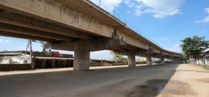
Fig 6. Pic of ROB (Source : Author)
Urban development has also accelerated over the last decade. New residential colonies, commercial buildings, shopping complexes, banks, hotels, restaurants, coaching institutes, hospitals, and educational institutions have been established, particularly along Dumra Road and around Mehsaul Chowk. As commercial activities expanded beyond the traditional market areas, land values increased and new business opportunities were created. Mehsaul Chowk has gradually emerged as one of the fastest-growing commercial centres in Sitamarhi.
The economic growth of the district has been supported by the expansion of retail businesses, banking services, transport facilities, and small-scale commercial enterprises. Its strategic location near the Indo–Nepal border has strengthened trade and transportation activities, contributing to local employment and business development. At the same time, improvements in education and healthcare infrastructure have enhanced the quality of public services, with the establishment of new schools, colleges, coaching centres, government hospitals, and private healthcare facilities.
Digital infrastructure has also improved considerably during this period. Online government services, digital banking, internet connectivity, and electronic payment systems have become more accessible. Many public places now have better street lighting, CCTV surveillance, and improved civic facilities, supporting safer and more efficient urban management.
Despite these developments, Sitamarhi still faces several urban challenges. Rapid urbanization has resulted in heavy traffic congestion, especially at major junctions such as Mehsaul Chowk. Inadequate drainage systems often cause waterlogging during the monsoon season. Roadside encroachments, insufficient parking facilities, lack of pedestrian infrastructure, and limited green spaces continue to affect the overall quality of the urban environment. Increasing vehicle ownership has also contributed to air and noise pollution.
Overall, the last decade has marked a significant phase of transformation for Sitamarhi district. Continuous investment in road infrastructure, commercial development, public services, and transportation has strengthened its role as an important urban centre in North Bihar. With the completion of ongoing projects such as the Road Over Bridge (ROB), improved traffic management, better public spaces, and sustainable urban planning, Sitamarhi has the potential to become a more organized, accessible, and environmentally sustainable city in the coming years.
5. RECOMMENDATIONS
Based on the detailed site analysis, traffic study, infrastructure assessment, environmental evaluation, and SWOT analysis, several recommendations are proposed to improve the overall quality and functionality of Mehsaul Chowk. The completion of the ongoing Road Over Bridge (ROB) should be given the highest priority, as it will significantly reduce traffic congestion caused by Railway Level Crossing No. 56 and improve the overall traffic flow. After the completion of the flyover, the space beneath it should be developed as a well-planned public plaza with organized parking facilities, dedicated e-rickshaw stands, pedestrian waiting areas, landscaped green spaces, seating zones, and recreational spaces for the public.
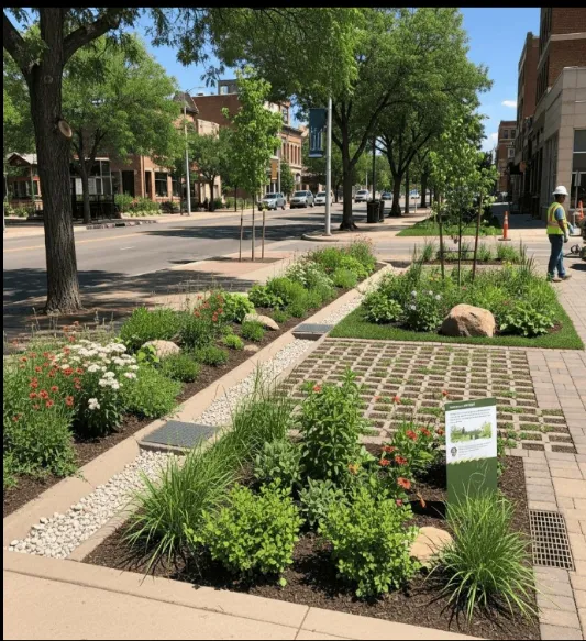
Fig 7. Green area (Source: Goggle)
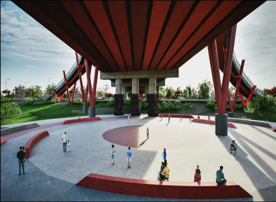
Fig 8. Plaza under ROB (Source: Goggle)
To improve road safety and mobility, continuous footpaths should be constructed on both sides of Dumra Road along with zebra crossings, pedestrian signals, ramps, tactile paving, and proper street lighting. Dedicated turning lanes, clear road markings, traffic signs, and smart traffic signals should also be introduced to reduce traffic conflicts and improve vehicle movement. Organized parking facilities for cars, motorcycles, bicycles, and public transport should be developed to eliminate random roadside parking, while designated pick-up and drop-off points should be provided for buses, auto-rickshaws, and e-rickshaws.
Environmental quality can be enhanced by increasing roadside plantation, developing landscaped medians, and introducing green infrastructure such as rain gardens, bioswales, and rainwater harvesting systems. The drainage network should be upgraded to prevent waterlogging during the monsoon season, while solid waste management should be strengthened through the installation of public dustbins and regular municipal waste collection. Overhead utility lines may gradually be shifted underground to improve both safety and the visual appearance of the urban environment.
The cultural identity of Sitamarhi should also be reflected in the redevelopment of Mehsaul Chowk. Public spaces can incorporate Mithila art, local sculptures, decorative lighting, and culturally inspired street furniture to create a unique urban character. Planned vending zones should be provided for street vendors to support local businesses while preventing encroachment on pedestrian pathways.
In the long term, the redevelopment of Mehsaul Chowk should follow the principles of sustainable and people-oriented urban planning. Future development should encourage walking, cycling, and the use of public transport while preserving green open spaces and improving accessibility for all users. By integrating efficient traffic management, modern infrastructure, environmental sustainability, and public-oriented urban design, Mehsaul Chowk can be transformed into a safe, attractive, and well-organized urban gateway that supports the future growth and development of Sitamarhi district.
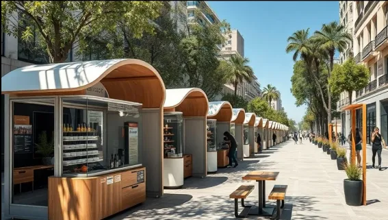
Fig 9. Footpath way (Source: Goggle)
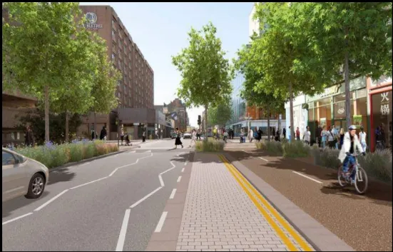
Fig 10. Vendors shop (Source: Goggle)
CONCLUSION
This research study concludes that Mehsaul Chowk is one of the most significant urban junctions in Sitamarhi district because of its strategic location, high commercial activity, and strong transportation connectivity. It functions as the main link between Sitamarhi town and Dumra, supporting the movement of people, goods, and services throughout the district. Over the last two decades, rapid urbanization, population growth, and commercial expansion have transformed the area from a small agricultural settlement into a major commercial and transportation hub.
The study reveals that although Mehsaul Chowk has excellent regional connectivity and economic importance, its existing infrastructure has not developed at the same pace as urban growth. Heavy mixed traffic, frequent congestion near Railway Level Crossing No. 56, lack of organized parking, inadequate pedestrian facilities, poor drainage, roadside encroachments, and limited green spaces have reduced the efficiency, safety, and environmental quality of the junction. These issues affect both traffic operations and the overall public experience.
Site observations and traffic analysis indicate that the current road network is unable to accommodate the increasing number of vehicles and pedestrians. The absence of proper traffic management measures, dedicated pedestrian infrastructure, and planned public spaces creates continuous conflicts between different road users. Environmental problems such as dust, noise pollution, urban heat, and waterlogging further reduce the quality of the urban environment.
The ongoing Road Over Bridge (ROB) project presents an important opportunity to transform Mehsaul Chowk into a well-organized and sustainable urban node. By separating through traffic from local traffic, improving pedestrian facilities, developing organized parking, strengthening drainage systems, increasing green infrastructure, and creating attractive public spaces beneath the flyover, the junction can function more efficiently while enhancing public safety and environmental quality.
Overall, this study demonstrates that the future development of Mehsaul Chowk should follow the principles of sustainable urban planning, integrated transportation, and people-oriented design. With proper planning, effective traffic management, environmental improvements, and coordinated infrastructure development, Mehsaul Chowk has the potential to become a safe, accessible, environmentally responsive, and vibrant public space. The proposed recommendations can serve as a practical framework for future urban development projects in Sitamarhi and may also provide guidance for the redevelopment of similar medium-sized urban junctions across Bihar.
REFERENCES
The following references were used for the preparation of this research work on Mehsaul Chowk, Sitamarhi, Bihar.
Government Reports and Official Sources
Maps and Spatial Data
Books
Research Papers and Online Sources
Source of Figures
Maps and Spatial Data
Books
Research Papers and Online Sources
Source of Figures

Avantika Swaraj*, Madhavendra Pratap Singh, Arun Kapur, Research Paper On Urban Tranformation Of Mehsaul Chowk, Sitamarhi, Bihar, Int. J. Sci. R. Tech., 2026, 3 (9), 620-630. https://doi.org/10.5281/zenodo.22976007
 10.5281/zenodo.22976007