

We use cookies to ensure our website works properly and to personalise your experience. Cookies policy
Department Of Amity School Of Architecture And Planning, Lucknow Campus
Rapid urbanisation in small and emerging towns is transforming traditional settlement patterns, increasing traffic movement, commercial activity and pressure on public spaces. However, the growth of such towns often occurs without adequate transport planning, pedestrian infrastructure or public-space management. This study examines Patel Chowk in Sikandra, Kanpur Dehat, Uttar Pradesh, as a representative emerging urban node where commercial, institutional, residential and transport activities converge. The study analyses existing land use, road characteristics, traffic movement, pedestrian activity, parking, informal vending and accessibility within an approximately 500 m radius of Patel Chowk. Field observations and traffic surveys conducted during May–June 2026 indicate that motorcycles form the dominant component of vehicular movement, while pedestrian activity is highest during the evening period. The study identifies congestion, roadside parking, mixed traffic, informal encroachment, discontinuous pedestrian infrastructure, unmanaged public transport stopping and inadequate universal accessibility as major concerns. Based on the findings, the study proposes an integrated approach combining parking management, pedestrian-oriented street design, junction improvement, organised vending, public transport management and streetscape enhancement. The study argues that timely intervention at strategic town centres can improve mobility and public-space quality while preparing emerging towns for future urban growth.
Large cities such as Kanpur function as employment and economic centers. Smaller towns like Sikandra support these cities by providing workforce, services, agricultural trade, and residential opportunities. With improving highways, industrial development, and regional connectivity, Sikandra is gradually transforming from a rural service town into an emerging urban center.
As this transformation continues, the town will experience higher traffic volumes, commercial expansion, and increased population movement. If these changes are not supported by proper urban planning, problems such as traffic congestion, parking shortages, unsafe pedestrian movement, and unorganized commercial growth will become more severe.
Therefore, it is important to study the existing transportation system and propose planning strategies before these issues become critical.
2. RESEARCH PROBLEM
2.1 Research Problem
Sikandra is currently functioning as a feeder town for Kanpur by supplying workforce and essential services. Similar to how Noida and Gurugram evolved as supporting cities for Delhi, Sikandra has the potential to become an important satellite town in the Kanpur region.
However, the existing transportation infrastructure around Patel Chowk has not been planned for future growth. Increasing commercial activities, mixed land use, roadside parking, informal vending, and rising traffic demand indicate the need for proactive urban planning.
2.2 Aim
The aim of this study is to analyse the existing urban transport and public-space conditions around Patel Chowk, Sikandra, and to develop planning and urban-design strategies that can support safer, more accessible and more organised future growth.
2.3 Objectives
The study examines the existing land-use pattern and transportation network around Patel Chowk, analyses vehicular and pedestrian movement, identifies major accessibility and public-space problems, evaluates the interaction between formal and informal activities, and proposes context-sensitive interventions for improving mobility and public-space quality.
2.4 Research Gap
Existing planning approaches frequently focus on large cities, while smaller towns receive comparatively limited attention despite their increasing population, commercial activity and regional importance. There is a need for locally grounded studies that examine how transport, pedestrian movement, parking and informal activities interact within small-town centres. This research attempts to address this gap through a focused study of Patel Chowk and its surrounding urban fabric.
2.5 Hypothesis
If transport infrastructure, pedestrian facilities, parking, informal activities and public spaces around Patel Chowk are planned as an integrated system, the town centre can accommodate increasing urban activity with improved mobility, safety, accessibility and public-space quality.
2.6 Scope of Study
The study is limited to Patel Chowk and an approximately 500 m surrounding area. It primarily examines road movement, pedestrian accessibility, parking, market activity, land use and public-space conditions. The research focuses on existing conditions and planning interventions rather than detailed structural design or long-term traffic modelling.
2.7 Research Methodology
The study follows a mixed observational and analytical approach. Primary data were collected through field visits, photographic documentation, road measurements, traffic observations and pedestrian observations during May–June 2026. Secondary information was obtained from available planning guidelines, maps and published literature.
The study area was delineated using Patel Chowk as the central reference point and an approximate 500 m radius to capture the major streets and activities influencing the junction. Land-use observations were used to understand the spatial structure, while road measurements were used to examine carriageway width, right-of-way and pedestrian facilities.
3. STUDY AREA PROFILE
3.1 Site Location
Sikandra is a town and tehsil headquarters in Kanpur Dehat district of Uttar Pradesh, located approximately 80 km southwest of Kanpur. The town occupies an important position within the regional network due to its connections with surrounding settlements and market centres. Patel Chowk is situated within the built-up core of Sikandra and functions as a major urban intersection and activity node.
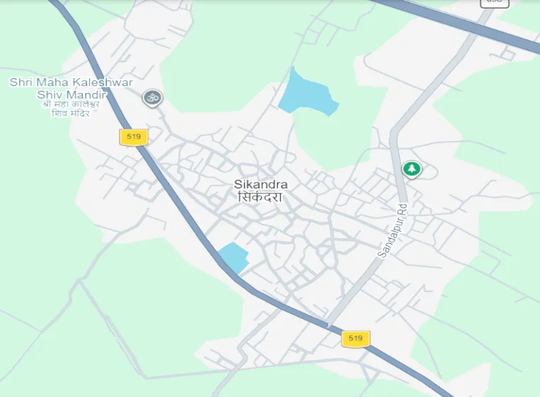
Fig.1: MAP (Source: Google earth)
3.2 Demographic Profile
According to the study data, Sikandra recorded an urban population of approximately 13,580 in Census 2011. The settlement has continued to experience increasing commercial and institutional activity, resulting in greater pressure on its existing transport infrastructure. Although the scale of development is smaller than that of metropolitan centres, the concentration of activities around the town centre creates significant local movement and public-space demand.
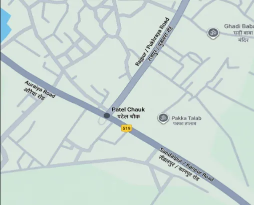
Fig.2: MAP (Source: Google earth)
3.3 Regional Connectivity
Patel Chowk is connected to important routes leading towards Auraiya, Pukhrayan and Sandalpur and indirectly serves movement towards other nearby settlements. These roads carry a combination of local and regional traffic. The junction therefore functions not only as a neighbourhood intersection but also as a point of transfer between different movement patterns.
4. EXISTING LAND USE:
Use Pattern The study area exhibits a land-use pattern, which is typical of developing Indian towns. The dominant land uses include shops and retail establishments residential 6 buildings, banks and financial institutions educational institutions, healthcare facilities and pharmacies, restaurants and food outlets government offices, petrol pump, religious places and informal roadside vendors. This mixture of activities generates movement throughout the day and contributes to the vitality of the urban environment. However the close
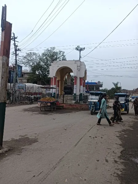
Fig.3:main chowk (Source: By Author)
Aproximity of land uses also creates competition for limited road space particularly during market hours.
4.1 TRANSPORTATION NETWORK:
Sikandra has a road-based transportation system with motorcycles, cars, auto-rickshaws, e-rickshaws, bicycles, buses, tractors, and goods vehicles. Patel Chowk carries both local and regional traffic, with congestion increasing during peak hours due to roadside parking, loading activities, and informal vending.
|
Road Name |
Road Type |
Total ROW (m) |
Carriageway (m) |
Pedestrian Pathway (Left) |
Pedestrian Pathway (Right) |
Traffic Direction |
Major Land Use |
|
Auraiya Road |
Primary Arterial Road |
12.0 m |
9.0 m |
1.5 m |
1.5 m |
Two-Way |
Hospitals, Retail Shops, Banquet Halls, Petrol Pump |
|
Pukhraya Road |
Primary Arterial Road |
12.0 m |
9.0 m |
1.5 m |
1.5 m |
Two-Way |
Commercial Shops, Banks, Mixed Use |
|
Sandalpur Road |
Secondary Collector Road |
9.0 m |
6.0 m |
1.5 m |
1.5 m |
Two-Way |
Residential, Local Shops, Institutions |
|
Market Road |
Local Commercial Street |
6.0 m |
4.5 m |
1.5 m |
_ |
One-Way (Mixed Traffic) |
Vegetable Market, Retail Shops, Informal Vendors |
Table No. 1: Existing Street Dimensions Around Patel Chowk
5. EXISTING LAND USE ANALYSIS
The area around Patel Chowk has a mix of uses. There are shops, homes, schools and government buildings all close together. This mix is what makes the area so lively.
Here's how the land is used:
We noticed that most shops are on the ground floor and homes are upstairs. There are also a lot of grocery stores, pharmacies and restaurants around Patel Chowk.
|
Land Use |
Approximate Share |
|
Commercial |
42% |
|
Residential |
30% |
|
Institutional |
10% |
|
Public & Government |
8% |
|
Transportation & Roads |
7% |
|
Open Spaces |
3% |
Table no.2: Total land use
5.1 TRAFFIC VOLUME SURVEY:
The traffic survey recorded 218 vehicle movements during the morning observation period, 344 during the afternoon period and 415 during the evening period. The evening period therefore represented the highest observed vehicular activity. Pedestrian observations recorded 240 pedestrians in the morning, 250 in the afternoon and 310 in the evening, giving a total of 800 observed pedestrian movements.
5.2 PEDESTRIAN MOVEMENT ANALYSIS
The pedestrian movement survey revealed that Patel Chowk experiences continuous pedestrian activity throughout the day because of the presence of retail shops, educational institutions, healthcare facilities, banks, and the traditional vegetable market. The majority of pedestrians were adult males (45%), followed by adult females (35%), students (15%), and senior citizens (5%). Although pedestrian movement is high, the existing walking environment is inadequate. Many pedestrians are forced to walk on the carriageway due to damaged or discontinuous footpaths and encroachments by roadside vendors. In addition, the absence of designated pedestrian crossings reduces safety and creates conflicts between pedestrians and moving vehicles.
|
Vehicle Type |
Morning |
Afternoon |
Evening |
|
Motorcycles |
120 |
215 |
275 |
|
Cars |
35 |
55 |
65 |
|
Auto / E-rickshaw |
30 |
28 |
25 |
|
Bicycles |
10 |
15 |
18 |
|
Tractor |
05 |
08 |
10 |
|
Bus |
10 |
08 |
12 |
|
Goods Vehicles |
08 |
15 |
10 |
|
Pedestrians |
240 |
250 |
310 |
Table.3: traffic Survey
|
User Category |
Percentage |
|
Adult Male |
45% |
|
Adult Female |
35% |
|
Students |
15% |
|
Senior Citizens |
5% |
Table no. 4: pedestrian count
6. PROBLEM AND ACCESSIBILITY ANALYSIS
6.1 Traffic and Junction Conflicts
The major traffic-related problems observed at Patel Chowk include mixed traffic, peak-hour congestion, roadside parking, loading activity and insufficient junction management. The concentration of different vehicle types within a limited road space results in irregular movement patterns. The absence of clearly defined crossing locations also increases pedestrian exposure to traffic.
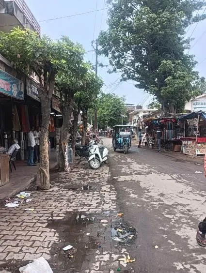
Fig.4: pedestrian (Source: By Author)
6.2 Pedestrian Accessibility
Pedestrian movement is constrained by discontinuous footpaths, encroachments, parked vehicles and inconsistent edge conditions. In several locations, pedestrians are forced to share the carriageway with moving vehicles. The problem becomes more significant during evening peak activity when both traffic and pedestrian volumes are high.
6.3 Parking and Roadside Encroachment
Unregulated parking reduces the usable road width and affects traffic flow. Commercial extensions and informal vending further reduce the effective pedestrian zone. Parking management should therefore be treated as part of the overall street-design strategy rather than as an isolated issue.
6.4 Market and Informal Activity Conflicts
Informal vendors are an integral part of the local commercial environment. However, when vending occurs directly within pedestrian movement paths or carriageways, it creates conflict. A more appropriate strategy is to identify and organise vending areas while retaining convenient access to customers.
6.5 Universal Accessibility
The existing environment has deficiencies related to ramps, tactile guidance, crossing facilities and accessible movement. Universal accessibility should be incorporated into future improvements so that children, elderly users and persons with disabilities can move independently and safely.
6.6 Key Issues Identified
The overall analysis indicates that the major concerns are congestion, mixed traffic, roadside parking, informal encroachment, discontinuous pedestrian infrastructure, absence of designated crossings, unmanaged public transport stopping, poor junction organisation, loading and unloading on roads, inadequate landscaping and signage, poor road maintenance and insufficient universal accessibility.
7. URBAN DESIGN PROPOSALS
7.1 Parking Management
Parking should be shifted from unregulated roadside occupation towards clearly designated parking locations wherever spatially feasible. Short-duration parking can be managed near commercial areas, while longer-duration parking should be encouraged away from the immediate junction. Motorcycle parking should be organised separately where possible to prevent random occupation of pedestrian areas. Parking management should be supported through signage and enforcement.
7.2 Pedestrian Infrastructure Improvement
Continuous and obstruction-free pedestrian paths should be established along the major streets. Existing footpaths should be repaired and connected across junctions, commercial frontages and important activity points. Pedestrian crossings should be introduced at logical desire lines and supported by appropriate signage and visibility improvements. The design should follow applicable pedestrian and street-design guidance.
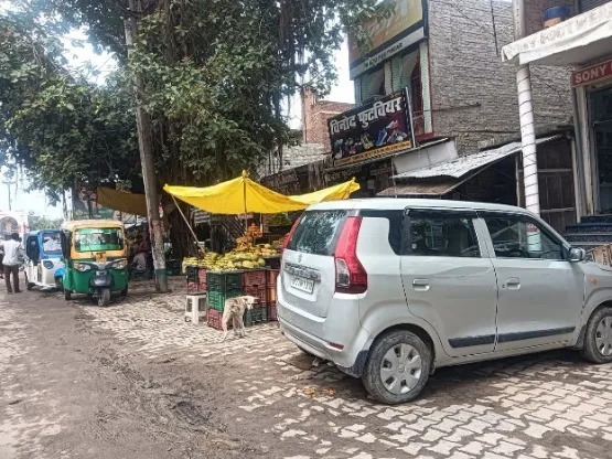
Fig.5: parking (Source: By Author)
7.3 Junction and Traffic Management
Patel Chowk should be treated as a coordinated junction rather than as an isolated road intersection. Approach-side parking and unnecessary stopping should be controlled, turning movements should be clearly organised and traffic signage should be improved. Traffic calming may be considered on streets where pedestrian activity is particularly high. The objective should be to improve movement efficiency without encouraging excessive vehicle speeds.
7.4 Market Reorganisation and Vendor Management
The market area should be reorganised so that vending and pedestrian movement can coexist. Designated vending zones can be identified along suitable edges while maintaining a continuous pedestrian corridor. Loading and unloading should be shifted to controlled locations and, where feasible, managed during lower-traffic periods. Such an approach can improve circulation while protecting the economic role of local vendors.
7.5 Public Transport Management
Bus and auto/e-rickshaw stopping points should be clearly identified and located away from critical junction conflict areas wherever possible. Passenger waiting areas should be connected to pedestrian paths. Organised para-transit stopping can reduce random stopping and improve both road efficiency and passenger safety.
7.6 Universal Accessibility Measures
Future street improvements should incorporate accessible ramps, tactile guidance where appropriate, obstruction-free walking surfaces and safe pedestrian crossings. Accessibility should be considered continuously along the route rather than only at individual buildings. Public buildings and important commercial destinations should have accessible connections to the main pedestrian network.
7.7 Streetscape and Public Space Improvement
Small-scale public-space improvements can significantly enhance the character of Patel Chowk. Street trees, appropriate landscaping, seating at suitable locations, improved lighting, signage and visually organised commercial edges can create a more comfortable public environment. The design should remain simple and durable so that maintenance requirements remain manageable for a small town.
7.8 Intervention Strategy
The improvement process can be implemented in phases. Short-term interventions should focus on parking control, removal of dangerous obstructions, traffic signage, pedestrian crossings and organised stopping areas. Medium-term interventions should include continuous footpaths, market reorganisation, improved junction geometry and accessible street infrastructure. Long-term interventions should focus on integrated transport planning, public-space development, stronger land-use management and coordinated urban expansion.
8. FUTURE DEVELOPMENT VISION
8.1 Future Mobility Scenario
As Sikandra grows, the demand for mobility is expected to increase along with commercial and institutional activity. Future transport planning should therefore prioritise a balanced system in which walking, cycling, public transport, para-transit and private vehicles can coexist. The objective should not simply be to increase road capacity but to improve the efficiency and safety of the entire movement system.
8.2 Patel Chowk as a Regional Urban Node
Patel Chowk has the potential to develop as a stronger urban node within Sikandra because of its strategic location and concentration of activities. Rather than allowing incremental growth to intensify existing conflicts, future development should strengthen the relationship between transport infrastructure, commercial activity and public space. A well-managed town centre can support local economic activity while also creating a more legible and accessible urban environment.
8.3 Phased Development Strategy
Future growth should follow a phased approach in which immediate mobility problems are addressed before development intensity increases further. Pedestrian and parking management should be established first, followed by improvements to junctions, public transport, market organisation and streetscape. Long-term development should integrate these improvements with broader land-use and infrastructure planning for the town.
9. DISCUSSION
9.1 Major Findings
The study demonstrates that Patel Chowk is already experiencing the pressures associated with an emerging urban centre. The dominance of motorcycles, increasing evening traffic, significant pedestrian movement and concentration of commercial uses indicate a high level of activity within a relatively constrained street environment. The major problem is not simply insufficient road width but the competition between movement, parking, vending, loading, commercial access and pedestrian activity.
The findings also show that pedestrian accessibility is closely connected to traffic and land-use conditions. Where commercial activity intensifies, demand for parking, loading and pedestrian access increases simultaneously. Without coordinated management, these activities occupy the same limited road space and generate conflict. Therefore, transport planning for small towns should be integrated with urban design and public-space planning.
9.2 Implications for Emerging Small Towns
The conditions observed at Patel Chowk are relevant to other emerging towns where urban growth occurs incrementally without sufficient infrastructure upgrades. Early intervention can be more effective and economical than attempting to correct heavily congested conditions after uncontrolled growth has taken place. Small-town planning should recognise existing local economic and social patterns while gradually improving safety, accessibility and movement.
9.3 Limitations
The study is based primarily on field observations and a limited-period traffic survey conducted during May–June 2026. The analysis does not include detailed origin-destination surveys, annual traffic growth projections, parking accumulation studies or long-term demographic forecasting. Therefore, the proposed interventions should be considered planning and urban-design recommendations that require further technical assessment before implementation.
CONCLUSION
Patel Chowk represents the changing character of an emerging small-town centre where commercial growth, regional connectivity and local mobility are creating increasing pressure on existing streets and public spaces. The study found that motorcycles are the dominant vehicle type, evening represents the highest observed traffic and pedestrian activity, and several competing activities occupy the same limited street space. Parking, informal vending, loading, public transport stopping and pedestrian movement currently interact in an uncoordinated manner.
The study concludes that the future of Patel Chowk should not be addressed only through road widening or increased vehicle capacity. A more sustainable approach is to create an integrated movement and public-space system that prioritises pedestrian safety, organised parking, efficient public transport, managed vending, accessible infrastructure and improved streetscape quality. Such interventions can strengthen Patel Chowk as an important urban node while allowing Sikandra to accommodate future growth in a more organised manner.
The case of Patel Chowk demonstrates that emerging towns have an opportunity to address mobility and public-space challenges before they reach the scale and complexity commonly experienced in larger cities. Context-sensitive, phased and people-oriented planning can help small towns retain their local character while becoming safer, more accessible and better prepared for future urban development.
REFERENCES


Jigyasa Katiyar*, Madhavendra Pratap Singh, Arun Kapur, Preparing Emerging Towns For Future Urban Growth: Urban Transport And Public Space Analysis Of Patel Chowk, Sikandra, Uttar Pradesh, Int. J. Sci. R. Tech., 2026, 3 (9), 475-483. https://doi.org/10.5281/zenodo.22916389
 10.5281/zenodo.22916389